
File:Bevölkerungsentwicklung Ahrensfelde.svg

Size of this PNG preview of this SVG file: 800 × 559 pixels. Other resolutions: 320 × 224 pixels | 640 × 448 pixels | 1,024 × 716 pixels | 1,280 × 895 pixels | 2,560 × 1,790 pixels | 1,011 × 707 pixels.
Original file (SVG file, nominally 1,011 × 707 pixels, file size: 272 KB)
| This is a file from the Wikimedia Commons. Information from its description page there is shown below. Commons is a freely licensed media file repository. You can help. |
Summary
| Description |
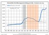
Deutsch: Bevölkerungsentwicklung in den heutigen Grenzen von Ahrensfelde, Landkreis Barnim, Land Brandenburg, Deutschland
Blaue Linie: Bevölkerung -- Punktierte Linie: Vergleich mit der Entwicklung Brandenburgs Grauer Hintergrund: Zeit der Nazi-Herrschaft -- Roter Hintergrund: DDR-Zeit English: Population development within the current boundaries of Ahrensfelde, Barnim district, Brandenburg state, Germany
Blue line: Population -- Dotted line: Comparison to population development of Brandenburg state Grey background: Time of nazi rule -- Red background: Time of communist rule 中文:人口发展在今天的阿伦斯费尔德边界内,巴尔尼姆县,勃兰登堡州,德国
蓝线:人口 -- 虚线:与勃兰登堡州发展的比较 灰色背景:纳粹统治时期 -- 红色背景:德意志民主共和国时期 Español: Desarrollo de la población en los actuales límites de Ahrensfelde, distrito de Barnim, estado de Brandenburg, Alemania
Línea azul: Habitantes -- Línea de puntos: Comparación con el desarrollo de Brandenburgo Fondo gris: Período del gobierno nazi -- Fondo Rojo: Época communista Français : Développement de la population dans les limites actuelles de Ahrensfelde, arrondissement de Barnim, Land de Brandebourg, Allemagne
Ligne bleue: Population -- Ligne pointillé: Comparaison avec le développement de Brandebourg Fond gris: Période du régime nazie -- Fond rouge: Période du régime communiste Italiano: Sviluppo della popolazione entro gli attuali confini de Ahrensfelde, circondario de Barnim, stato federato de Brandeburgo, Germania
Linea Blu: Popolazione -- Linea puntata: Confronto dello sviluppo della popolazione dello stato del Brandenburgo Sfondo grigio: Ai tempi del governo nazista -- Sfondo rosso: Al tempo del governo comunista Nederlands: Ontwikkeling van de bevolking binnen de huidige grenzen van Ahrensfelde, landkreis Barnim, deelstaat Brandenburg, Duitsland
Blauwe lijn: Bevolking -- Stippellijn: Vergelijking van de ontwikkeling van de bevolking van de deelstaat Brandenburg Grijze achtergrond: tijdens de nazi-regering -- Rode achtergrond: tijdens de communistische regering Polski: Rozwój ludności w obecnych granicach dla Ahrensfelde, powiat Barnim, kraj Brandenburgia, Niemcy
Niebieska linia: Populacja -- Linia przerywana: Porównanie z rozwoju Brandenburgii Szare tło: Okres hitlerowców -- Czerwone tło: Okres rządów komunistycznych Svenska: Befolkningsutvecklingen i de nuvarande gränserna för Ahrensfelde, landkreis Barnim, delstaten Brandenburg, Tyskland Blå linje: Befolkning -- Prickade linjen: Jämförelse med utvecklingen av Brandenburg Grå bakgrund: Period av Nazi styre -- Röd bakgrund: Period av kommunistiskt styre |
| Date | between 29 April 2012 and 19 June 2021 |
| Source |
Own work based on: Population Projection Brandenburg at Wikimedia Commons |
| Author | Hans G. Oberlack |
| Permission (Reusing this file) |
I, the copyright holder of this work, hereby publish it under the following license: This file is licensed under the Creative Commons Attribution-Share Alike 3.0 Unported license.
|
| Latest population data | 2020 |
| Object location | | View this and other nearby images on: OpenStreetMap |
|---|
File history
Click on a date/time to view the file as it appeared at that time.
| Date/Time | Thumbnail | Dimensions | User | Comment | |
|---|---|---|---|---|---|
| current | 04:43, 20 January 2024 | | 1,011 × 707 (272 KB) | Zhing'za zï Ïnin | fixed broken text spacing/Der unterbrochene Textabstand wurde behoben |
| 04:41, 20 January 2024 |  | 1,011 × 707 (41 KB) | Zhing'za zï Ïnin | {{Information |Description= {{de|1=Bevölkerungsentwicklung in den heutigen Grenzen von '''Ahrensfelde''', Landkreis Barnim, Land Brandenburg, Deutschland<br>Blaue Linie: Bevölkerung -- Punktierte Linie: Vergleich mit der Entwicklung Brandenburgs <br>Grauer Hintergrund: Zeit der Nazi-Herrschaft -- Roter Hintergrund: DDR-Zeit}} {{en|1=Population development within the current boundaries of '''Ahrensfelde''', Barnim district, Brandenburg state, Germany<br>Blue line: Population -- Dotted line: Co... |
File usage
The following pages on the English Wikipedia use this file (pages on other projects are not listed):