
Portal:New South Wales
The New South Wales Portal


New South Wales (commonly abbreviated as NSW) is a state on the east coast of Australia. It borders Queensland to the north, Victoria to the south, and South Australia to the west. Its coast borders the Coral and Tasman Seas to the east. The Australian Capital Territory and Jervis Bay Territory are enclaves within the state. New South Wales' state capital is Sydney, which is also Australia's most populous city. , the population of New South Wales was over 8.3 million, making it Australia's most populous state. Almost two-thirds of the state's population, 5.3 million, live in the Greater Sydney area.
The Colony of New South Wales was founded as a British penal colony in 1788. It originally comprised more than half of the Australian mainland with its western boundary set at 129th meridian east in 1825. The colony then also included the island territories of Van Diemen's Land, Lord Howe Island, and Norfolk Island. During the 19th century, most of the colony's area was detached to form separate British colonies that eventually became the various states and territories of Australia and, arguably, New Zealand. The Swan River Colony (later called the Colony of Western Australia) was never administered as part of New South Wales. (Full article...)
 Recognized content -
-


Alloxylon pinnatum, known as Dorrigo waratah, is a tree of the family Proteaceae found in warm-temperate rainforest of south-east Queensland and northern New South Wales in eastern Australia. It has shiny green leaves that are either pinnate (lobed) and up to 30 cm (12 in) long, or lanceolate (spear-shaped) and up to 15 cm (5.9 in) long. The prominent pinkish-red flower heads, known as inflorescences, appear in spring and summer; these are made up of 50 to 140 individual flowers arranged in corymb or raceme. These are followed by rectangular woody seed pods, which bear two rows of winged seeds.
Known for many years as Oreocallis pinnata, it was transferred to the new genus Alloxylon by Peter Weston and Mike Crisp in 1991. This genus contains the four species previously classified in Oreocallis that are found in Australasia. Its terminal globular flowers indicate that the species is pollinated by birds. Classified as near threatened under the Queensland Nature Conservation Act 1992, the Dorrigo waratah has proven difficult to keep alive in cultivation. (Full article...) -
Telopea speciosissima, commonly known as the New South Wales waratah or simply waratah, is a large shrub in the plant family Proteaceae. It is endemic to New South Wales in Australia. No subspecies are recognised, but the closely related Telopea aspera was only recently classified as a separate species. T. speciosissima is a shrub to 3 or 4 m (9.8 or 13.1 ft) high and 2 m (6.6 ft) wide, with dark green leaves. Its several stems arise from a pronounced woody base known as a lignotuber. The species is well renowned for its striking large red springtime inflorescences (flowerheads), each including hundreds of individual flowers. These are visited by the eastern pygmy possum (Cercartetus nanus), birds such as honeyeaters (Meliphagidae), and various insects.
The floral emblem for its home state of New South Wales, Telopea speciosissima has featured prominently in art, architecture, and advertising, particularly since Australian federation. Commercially grown in several countries as a cut flower, it is also cultivated in home gardens, requiring good drainage yet adequate moisture, but is vulnerable to various fungal diseases and pests. A number of cultivars with various shades of red, pink and even white flowers are available. Horticulturists have also developed hybrids with T. oreades and T. mongaensis which are more tolerant of cold, shade, and heavier soils. (Full article...) -
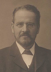
Richard Edward O'Connor QC (4 August 1851 – 18 November 1912) was an Australian politician and judge.
A barrister and later Queen's Counsel, O'Connor was active in the campaign for Australian Federation and was a close associate of Edmund Barton. He served as New South Wales Minister for Justice in the Dibbs ministry from 1891 to 1893 while a member of the New South Wales Legislative Council (1888–98), and was a member of the constitutional committee at the Federal Convention that drafted the Australian Constitution. A member of the first federal ministry as Vice-President of the Executive Council, O'Connor led the government in the Senate, the first person to do so, from 1901 to 1903, playing a key role in the development of that chamber's role in Australian politics. (Full article...) -
Reginald Walter Darcy Weaver (18 July 1876 – 12 November 1945) was an Australian conservative parliamentarian who served in the New South Wales Legislative Assembly for 28 years. Serving from 1917 in the backbenches, he entered the cabinet of Thomas Bavin in 1929 as Secretary for Mines and Minister for Forests until he returned to opposition in 1930. Following the success of the United Australia Party in the 1932 election, Weaver returned as the Secretary for Public Works and Minister for Health in the Stevens ministry.
In 1935 he was dropped from the ministry but was later elected as the Speaker of the New South Wales Legislative Assembly in 1937, holding office until the Mair Government lost power in 1941. Weaver then witnessed the death of the United Australia Party in 1943 and became the leader of the new Democratic Party in 1944. He was then involved in the negotiations to form the New South Wales branch of the Liberal Party, with Weaver becoming the first leader of the state Liberal Party in April 1945. He served only briefly until dying of a heart attack in November 1945. (Full article...) -
The Riverina (/ˌrɪvəˈriːnə/)
is an agricultural region of southwestern New South Wales, Australia. The Riverina is distinguished from other Australian regions by the combination of flat plains, warm to hot climate and an ample supply of water for irrigation. This combination has allowed the Riverina to develop into one of the most productive and agriculturally diverse areas of Australia. Bordered on the south by the state of Victoria and on the east by the Great Dividing Range, the Riverina covers those areas of New South Wales in the Murray and Murrumbidgee drainage zones to their confluence in the west.
Home to Aboriginal groups including the Wiradjuri people for over 40,000 years, the Riverina was colonised by Europeans in the mid-19th century as a pastoral region providing beef and wool to markets in Australia and beyond. In the 20th century, the development of major irrigation areas in the Murray and Murrumbidgee valleys has led to the introduction of crops such as rice and wine grapes. The Riverina has strong cultural ties to Victoria, and the region was the source of much of the impetus behind the federation of Australian colonies. (Full article...) -
The platypus (Ornithorhynchus anatinus), sometimes referred to as the duck-billed platypus, is a semiaquatic, egg-laying mammal endemic to eastern Australia, including Tasmania. The platypus is the sole living representative or monotypic taxon of its family Ornithorhynchidae and genus Ornithorhynchus, though a number of related species appear in the fossil record.
Together with the four species of echidna, it is one of the five extant species of monotremes, mammals that lay eggs instead of giving birth to live young. Like other monotremes, the platypus senses prey in cloudy water through electrolocation. It is one of the few species of venomous mammals, as the male platypus has a spur on the hind foot that delivers an extremely painful venom. (Full article...) -
The Inbetweeners 2 is a 2014 teen coming of age adventure sex comedy film and sequel to The Inbetweeners Movie (2011), which is based on the E4 sitcom The Inbetweeners. It was written and directed by series creators Damon Beesley and Iain Morris.
The film involves four school friends who meet up again for a holiday in Australia, and stars Simon Bird, Joe Thomas, James Buckley and Blake Harrison. In media interviews, the film's writers and actors stated that it was to be an end to the series. (Full article...) -
Lieutenant General Sir Iven Giffard Mackay, KBE, CMG, DSO & Bar, VD (7 April 1882 – 30 September 1966) was a senior Australian Army officer who served in both world wars.
Mackay graduated from the University of Sydney in 1904 and taught physics there from 1910 until 1914, when he joined the Australian Imperial Force shortly after the outbreak of the First World War. He served with the 4th Infantry Battalion at Gallipoli, where he distinguished himself in hand-to-hand fighting at the Battle of Lone Pine. In April 1916, he assumed command of the 4th Infantry Battalion on the Western Front and led it at the Battle of Pozières, Battle of Bullecourt and Battle of Broodseinde. He was promoted to brigadier general in June 1918, and led the 1st Infantry Brigade at the Battle of Hazebrouck, the Battle of Amiens and in the attack on the Hindenburg Line. (Full article...) -
Edward Pulsford (29 September 1844 – 29 September 1919) was an English-born Australian politician and free-trade campaigner.
Pulsford established a successful business with his father as commission agents in Yorkshire before moving his interests to New South Wales in 1883. There he became a vigorous campaigner for free trade, and was a co-founder of the Free Trade and Liberal Association in that colony, the body that would later become the machine behind the Free Trade Party. Although his attempts to enter the New South Wales Legislative Assembly were abortive, he was appointed to the Legislative Council in 1895 and served until 1901, when he was elected to the Senate. An uncompromising opponent of all forms of protectionism, following the 1909 Fusion of the anti-Labour forces he joined the Liberal Party only with reluctance. (Full article...) -
Persoonia terminalis, also known as the Torrington geebung, is a shrub belonging to the family Proteaceae, and native to northern New South Wales and southern Queensland in eastern Australia. Reported as a subspecies of Persoonia nutans in 1981, it was described as a species by Lawrie Johnson and his colleague Peter Weston in 1991.
Two subspecies—P. t. terminalis and P. t. recurva—are recognised; both are found on well-drained acidic soils in sclerophyll forests, and P. t. terminalis is also found on granite outcrops. Although similar in appearance, they differ in leaf length and curvature. Both have a restricted range, with P. t. terminalis found in an area of under 100 square kilometres (39 square miles; 25,000 acres). (Full article...) -
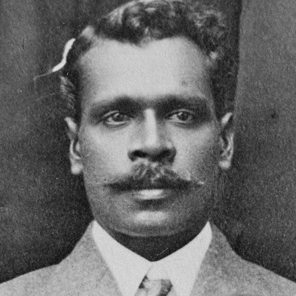
Jack Marsh (c. 1874 – 25 May 1916) was an Australian first-class cricketer of Australian Aboriginal descent who represented New South Wales in six matches from 1900–01 to 1902–03. A right-arm fast bowler of extreme pace, Marsh had high athletic qualities and was regarded as one of the outstanding talents of his era. His career was curtailed by continual controversy surrounding the legality of his bowling action; he was no-balled multiple times for throwing. As a result of the debate over the legitimacy of his action, Marsh never established himself at first-class level and was overlooked for national selection. In contemporary discourse, Marsh's lack of opportunities has often been attributed to racial discrimination.
Born into the Bundjalung people at Yulgilbar on the Clarence River in northern New South Wales, Marsh first made an impression as a professional runner, travelling to Sydney and then competing interstate, winning races as a sprinter and a hurdler. While in Sydney, Marsh began competing in the local club cricket competition and his action quickly came under scrutiny. He was first no-balled for throwing in 1897, but it was not until 1900 that he came to prominence in a trial match against the New South Wales state team. Marsh dismissed leading Test cricketers Victor Trumper and Monty Noble, but was called for throwing. Marsh vowed to prove the legitimacy of his action by bowling with his arm encased in splints, which prompted the umpire to resign in humiliation. Having topped the bowling averages in the local competition, Marsh was selected to make his debut in the Sheffield Shield. He made an immediate impression and led the first-class bowling averages for the season after three matches. He was no-balled in his second match by Bob Crockett, but things came to a head in his fourth match when the same umpire no-balled him seventeen times, leading to angry crowd demonstrations. The cricket community was divided on whether Marsh's action was fair and various theories were propounded, which sought to show a motive for foul play against Marsh. The most popular of these theories was that Marsh was scapegoated in a campaign against throwing and was a soft target because of his race. (Full article...) -
Central Area Command was one of several geographically based commands raised by the Royal Australian Air Force (RAAF) during World War II. It was formed in March 1940, and covered the central portion of New South Wales. Headquartered at Sydney, Central Area Command was responsible for air defence, aerial reconnaissance and protection of the sea lanes within its boundaries. It was disbanded in August 1941 and control of its units taken over by other RAAF formations. Proposals in 1943–44 to raise a new Central Area Command did not come to fruition. (Full article...) -

The Glasshouse arts and entertainment centre was central to the dismissal of Port Macquarie-Hastings Council
The dismissal of the Port Macquarie-Hastings Council on 27 February 2008 marked the end of a series of events involving a project which was initiated in 2001 in the New South Wales coastal town of Port Macquarie to build a cultural and entertainment centre, known to locals as the Glasshouse. The project, initially a joint venture with the management of the neighbouring shopping centre, Port Central, was originally expected to cost the Council A$7.3 million. However, by late 2007, despite the centre not yet having opened, the costs had blown out to over A$41.7 million, with interest repayments likely to extend the council's liability to A$66 million.
On 27 July 2007, a full public inquiry was announced by the Minister for Local Government, Paul Lynch. The inquiry reported its findings in February 2008. It found that the council had failed to provide appropriate financial and project management and had lost control of the costs, that the project costs had harmed the council's ability to provide services and amenities to the community, and that the council's communications management strategy had resulted in inadequate consultation with the public and inappropriate regard to their concerns. The Minister for Local Government dismissed the council and its mayor, Rob Drew, and appointed an administrator upon receiving the inquiry's report. Drew was critical of the process throughout, maintaining that errors had been made and misinformation had been accepted as fact; however, the New South Wales Urban Task Force, a property development lobby group, believed the sacking served as a warning to other councils to stick to "core responsibilities". (Full article...) -
Monaro Highway is a 285-kilometre-long (177 mi) highway in Victoria, New South Wales, and the Australian Capital Territory, in Australia, linking Cann River in Victoria to Canberra in the Australian Capital Territory (ACT) via the Monaro region. From its southern terminus, it follows the nearby Cann River upstream towards the New South Wales border through heavily forested terrain. Within New South Wales (NSW), it makes its way through further forest before reaching the pastures typical of the Monaro. There are multiple towns and villages along the highway, including Bombala, Nimmitabel, and Cooma. The terrain within the Monaro is largely hilly, and there are numerous crossings. The road also parallels the former Bombala railway line in several locations. Within the ACT, the road becomes a high volume roadway and serves the southern suburbs of Canberra. The highway has more recently had a grade-separated dual carriageway extension constructed within Canberra, as part of the Eastern Parkway construction project. It is designated part of route M23, and route A23 within Canberra, and route B23 within Victoria and New South Wales, with a concurrency where it also carries route B72 between the two sections of Snowy Mountains Highway. (Full article...) -
Mark Alan Webber AO (born 27 August 1976) is an Australian former racing driver who competed in Formula One from 2002 to 2013 and the FIA World Endurance Championship (WEC) between 2014 and 2016. He is a champion of the 2015 FIA WEC for Porsche with German Timo Bernhard and New Zealander Brendon Hartley.
Webber began karting at age 12 or 13 and achieved early success, winning regional championships before progressing to car racing in the Australian Formula Ford Championship and the British Formula 3 Championship. He competed for two years opposite Bernd Schneider in the FIA GT Championship with the AMG Mercedes team, finishing runner-up in the 1998 season with five wins in ten races before finishing second in the 2001 International Formula 3000 Championship driving for Super Nova Racing. Webber made his F1 debut with the Minardi team in the 2002 season and finished fifth in his first race, the Australian Grand Prix. He moved to the Jaguar squad for the 2003 and 2004 championships. For the 2005 season, he was granted an early release from his contract with Jaguar and joined the Williams team, securing his first podium finish at the Monaco Grand Prix. Webber remained at Williams until 2006, driving for the Red Bull team for the rest of his F1 career. He won nine F1 Grands Prix, thirteen pole positions and finished third in the World Drivers' Championship in the 2010, 2011 and 2013 seasons. (Full article...)


.jpg)


_Scottsdale.jpg)

.jpg)
.jpg)


Selected image

Bondi Beach is a popular beach and the name of the surrounding suburb in Sydney, Australia.
Related portals

(Northern
Territory) |
WikiProjects
Selected articles -
-
The Lamington National Park is a national park, lying on the Lamington Plateau of the McPherson Range on the Queensland/New South Wales border in Australia. From Southport on the Gold Coast the park is 85 kilometres (53 mi) to the southwest and Brisbane is 110 kilometres (68 mi) north. The 20,600 hectares (51,000 acres) Lamington National Park is known for its natural environment, rainforests, birdlife, ancient trees, waterfalls, walking tracks and mountain views. The park protects parts of the Eastern Australian temperate forests.
Protected areas to the east in Springbrook National Park and south along the Tweed Range in the Border Ranges National Park around Mount Warning in New South Wales conserve similar landscapes. The park is part of the Shield Volcano Group of the World Heritage Site Gondwana Rainforests of Australia inscribed in 1986 and added to the Australian National Heritage List in 2007. The park is part of the Scenic Rim Important Bird Area, identified as such by BirdLife International because of its importance in the conservation of several species of threatened birds. (Full article...) -
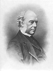
The first Cowper ministry was the second ministry of the Colony of New South Wales, and was led by Charles Cowper. It was the first of five occasions that Cowper was Leader of the Government. Cowper was elected in the first free elections for the New South Wales Legislative Assembly held in March 1856, and fought unsuccessfully with Stuart Donaldson to form Government. When Donaldson's Government faltered a little over two months after it was formed, Cowper formed Government.
The title of Premier was widely used to refer to the Leader of Government, but not enshrined in formal use until 1920. (Full article...) -
The Harts Buildings is a heritage-listed hotel and pub and former residence, located at 10–14 Essex Street, in the inner city Sydney suburb of The Rocks in the City of Sydney local government area of New South Wales, Australia. It was built from 1890 to 1899. It is also known as Hart's Buildings. The property is owned by Property NSW, an agency of the Government of New South Wales. It was added to the New South Wales State Heritage Register on 10 May 2002. (Full article...) -
The Parramatta River is an intermediate tide-dominated, drowned valley estuary located in Sydney, New South Wales, Australia. With an average depth of 5.1 metres (17 ft), the Parramatta River is the main tributary of Sydney Harbour, a branch of Port Jackson. Secondary tributaries include the smaller Lane Cove and Duck rivers.
Formed by the confluence of Toongabbie Creek and Darling Mills Creek at North Parramatta, the river flows in an easterly direction to a line between Yurulbin in Birchgrove and Manns Point in Greenwich. Here it flows into Port Jackson, about 21 kilometres (13 mi) from the Tasman Sea. The total catchment area of the river is approximately 252.4 square kilometres (97.5 sq mi) and is tidal to Charles Street Weir in Parramatta, approximately 30 kilometres (19 mi) from the Sydney Heads. (Full article...) -
Campbelltown is a suburb located on the outskirts of the metropolitan area of Sydney, New South Wales, Australia. It is located in Greater Western Sydney 53 kilometres (33 mi) south-west of the Sydney central business district by road. Campbelltown is the administrative seat of the local government area of the City of Campbelltown. It is also acknowledged on the register of the Geographical Names Board of New South Wales as one of only four cities within the Sydney metropolitan area.
Campbelltown gets its name from Elizabeth Campbell, the wife of former Governor of New South Wales Lachlan Macquarie. Originally called Campbell-Town, the name was later simplified to the current Campbelltown. (Full article...) -
Blackheath (postcode: 2785) is a town located near the highest point of the Blue Mountains, between Katoomba and Mount Victoria in New South Wales, Australia. The town's altitude is about 1,065 m (3,494 ft) AHD and it is located about 120 km (75 mi) west north-west of Sydney, 11 km (6.8 mi) north-west of Katoomba, and about 30 km (19 mi) south-east of Lithgow.
Blackheath has a vibrant artistic community and hosts two monthly markets – the Blackheath Growers Market and The Blackheath Community Market, as well as annual Christmas markets, antique markets and bimonthly craft markets. The town has many community activities, such as the Blackheath Philosophy Forum, which was founded in 2002 to arrange public discussion forums on philosophy and related topics. (Full article...) -
Maitland (/ˈmeɪtlənd/) is a city in the Hunter Valley of New South Wales, Australia and the seat of Maitland City Council, situated on the Hunter River approximately 166 kilometres (103 mi) by road north of Sydney and 35 km (22 mi) north-west of Newcastle. It is on the New England Highway approximately 17 km (11 mi) from its origin at Hexham.
At the 2021 census it had approximately 89,597 inhabitants, spread over an area of 392 square kilometres (151 sq mi), with most of the population located in a strip along the New England Highway between the suburbs of Lochinvar and Thornton respectively. The city centre is located on the right bank of the Hunter River, protected from moderate potential flooding by a levee. (Full article...) -
The Sydney Gay and Lesbian Mardi Gras or Sydney Mardi Gras is an event in Sydney, New South Wales attended by hundreds of thousands of people from around Australia and overseas. One of the largest LGBT festivals in the world, Mardi Gras is the largest Pride event in Oceania. It includes a variety of events such as the Sydney Mardi Gras Parade and Party, Bondi Beach Drag Races, Harbour Party, the academic discussion panel Queer Thinking, Mardi Gras Film Festival, as well as Fair Day, which attracts 70,000 people to Victoria Park, Sydney.
The Sydney Gay & Lesbian Mardi Gras is one of Australia's biggest tourist drawcards, with the parade and dance party attracting many international and domestic tourists. It is New South Wales' second-largest annual event in terms of economic impact, generating an annual income of about A$30 million for the state. (Full article...) -
The Bank of New South Wales (BNSW), also known commonly as The Wales, was the first bank in Australia, being established in Sydney in 1817 and situated on Broadway. During the 19th century, the bank opened branches throughout Australia and New Zealand, expanding into Oceania in the 20th century. It merged with many other financial institutions, finally merging with the Commercial Bank of Australia in 1982 and being renamed to the Westpac Banking Corporation on 4 May that year under the Bank of New South Wales (Change of Name) Act 1982. (Full article...) -
Northern Rivers is the most northeasterly region of the Australian state of New South Wales, located between 590 and 820 kilometres (370 and 510 mi) north of the state capital, Sydney, and encompasses the catchments and fertile valleys of the Clarence, Richmond, and Tweed rivers. It extends from Tweed Heads in the north (adjacent to the Queensland border) to the southern extent of the Clarence river catchment which lies between Grafton and Coffs Harbour, and includes the main towns of Tweed Heads, Byron Bay, Ballina, Kyogle, Lismore, Casino and Grafton. At its most northern point, the region is 102 kilometres (63 mi) south-southeast of the Queensland capital, Brisbane.
As with all regions of New South Wales, it has no official status, although state government department offices and local governments in the area work together for purposes such as tourism, education, water catchment management and waste management. This area has a mild, sub-tropical climate. Major industries are agriculture, fisheries, public services (particularly health) and tourism; the region is also popular for niche crops, hobby farmers, and retirees from life in the larger cities. (Full article...) -
Mount Warning (Bundjalung: Wollumbin), a mountain in the Tweed Range in the Northern Rivers region of New South Wales, Australia, was formed from a volcanic plug of the now-gone Tweed Volcano. The mountain is located 14 kilometres (9 mi) west-south-west of Murwillumbah, near the border between New South Wales and Queensland.
Lieutenant James Cook saw the mountain from the sea and named it Mount Warning. (Full article...) -
Carlingford (/ˈkɑːrlɪŋfərd/) is a suburb of Sydney, in the state of New South Wales, Australia. Carlingford is 22 kilometres north-west of the Sydney central business district in the local government area of City of Parramatta. Carlingford sits at the meeting point of Northern Sydney and Western Sydney sitting on both sides of Pennant Hills Road which generally acts as a divider of the two regions. While being part of City of Parramatta, it is sometimes referred to as being part of the Hills District. (Full article...) -
The Central Coast is a peri-urban region lying on the Pacific Ocean in northern-eastern New South Wales, Australia. The region is situated north of Sydney, which is filled with subtropical national parks, forests and also encompasses the major coastal waterways of Brisbane Water, Tuggerah Lakes and southern Lake Macquarie. The region's hinterland, which has fertile valleys, rural farmland and wineries, and also includes the Watagan Mountains. The Central Coast is known for its regional coastal towns like Terrigal, The Entrance, Ettalong Beach, Budgewoi and Bateau Bay with resorts and holiday parks, which feature many expansive beaches and lagoons with surfing and coastal tracks, as well as scenic views. Gosford is the main commercial hub and gateway.
The Central Coast includes major localities, villages and towns such as Gosford, Wyong, Terrigal, Woy Woy and The Entrance. The area is the third-largest urban area in New South Wales and the ninth-largest urban area in Australia. Geographically, the Central Coast is generally considered to include the region bounded by the Hawkesbury River in the south, the Watagan Mountains in the west and the southern end of Lake Macquarie, lying on the Sydney basin. (Full article...) -
The Murray River (in South Australia: River Murray) (Ngarrindjeri: Millewa, Yorta Yorta: Dhungala (Tongala)) is a river in Southeastern Australia. It is Australia's longest river at 2,508 km (1,558 mi) extent. Its tributaries include five of the next six longest rivers of Australia (the Murrumbidgee, Darling, Lachlan, Warrego and Paroo Rivers). Together with that of the Murray, the catchments of these rivers form the Murray–Darling basin, which covers about one-seventh the area of Australia. It is widely considered Australia's most important irrigated region.
The Murray rises in the Australian Alps, draining the western side of Australia's highest mountains, then meanders northwest across Australia's inland plains, forming the border between the states of New South Wales and Victoria as it flows into South Australia. From an east–west direction it turns south at Morgan for its final 315 km (196 mi), reaching the eastern edge of Lake Alexandrina, which fluctuates in salinity. The water then flows through several channels around Hindmarsh Island and Mundoo Island. There it is joined by lagoon water from The Coorong to the south-east before emptying into the Great Australian Bight (often referenced on Australian maps as the Southern Ocean) through the Murray Mouth, 10 km (6.2 mi) east of Goolwa South. Despite discharging considerable volumes of water at times, particularly before the advent of large-scale river regulation, the waters at the Murray Mouth are almost invariably slow and shallow. (Full article...) -
The Blue Mountains are a mountainous region and a mountain range located in New South Wales, Australia. The region is considered to be part of the western outskirts of the Greater Sydney area. The region borders on Sydney's main metropolitan area, its foothills starting about 50 kilometres (31 mi) west of centre of the state capital, close to Penrith. The public's understanding of the extent of the Blue Mountains is varied, as it forms only part of an extensive mountainous area associated with the Great Dividing Range. As defined in 1970, the Blue Mountains region is bounded by the Nepean and Hawkesbury rivers in the east, the Coxs River and Lake Burragorang to the west and south, and the Wolgan and Colo rivers to the north. Geologically, it is situated in the central parts of the Sydney Basin.
The Blue Mountains Range comprises a range of mountains, plateau escarpments extending off the Great Dividing Range about 4.8 kilometres (3.0 mi) northwest of Wolgan Gap in a generally southeasterly direction for about 96 kilometres (60 mi), terminating at Emu Plains. For about two-thirds of its length it is traversed by the Great Western Highway, the Main Western railway line and the soon to be completed, Blue Mountains tunnel. Several established towns are situated on its heights, including Katoomba, Blackheath, Mount Victoria, and Springwood. The range forms the watershed between Coxs River to the south and the Grose and Wolgan rivers to the north. The range contains the Explorer Range and the Bell Range. (Full article...)


.jpg)


Did you know (auto-generated)

- ... that Turkish international soccer player Rojin Polat was named member of the "2021 All Schools Merit Girls Team" in New South Wales, Australia?
- ... that the "Cuddle with a Koala" experience at Featherdale Wildlife Park was stopped in 1988 when New South Wales law was changed to restrict koala handling?
- ... that Victorian post office official William Rundell also collected stamps in his spare time, acquiring 48 copies of the "Sydney view" stamps of New South Wales?
General images -
-

-
 Olympic colours on the Sydney Harbour Bridge in the year 2000 (from History of New South Wales)
 -
 Early expeditions of Charles Sturt (from History of New South Wales)
 -
 Hyde Park, Sydney with the Australian Museum under construction in the distance, 1842 (from History of New South Wales)
 -
 Federation Pavilion, Centennial Park, Sydney, 1 January 1901. (from History of New South Wales)
 -
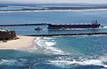 A bulk carrier entering the Port of Newcastle, New South Wales, 2009 (from Economy of New South Wales)
 -
 Humanitarian Caroline Chisholm provided support to poverty-stricken women migrants (from History of New South Wales)
 -
 Dry paddocks in the Riverina region during the 2007 drought (from History of New South Wales)
 -
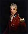 The 5th Governor of New South Wales, Lachlan Macquarie, was influential in establishing civil society in Australia (from History of New South Wales)
 -
 Governor Arthur Phillip hoists the British flag over the new colony at Sydney in 1788 (from History of New South Wales)
 -
 Murray Grey cows and calves (from Economy of New South Wales)
 -
 Landing of Lieutenant James Cook at Botany Bay, 29 April 1770 (from History of New South Wales)
 -
 A 630 lb gold specimen from Hill End, unearthed in 1872 (from History of New South Wales)
 -
 Tumut 3 Power Station was constructed as part of the vast Snowy Mountains Scheme in New South Wales (1949–1974). Construction necessitated the expansion of Australia's immigration program. (from History of New South Wales)
 -
 Aboriginal tribes in New South Wales, from an 1892 map (from History of New South Wales)
 -
 A General Chart of New Holland including New South Wales & Botany Bay with The Adjacent Countries and New Discovered Lands, published in An Historical Narrative of the Discovery of New Holland and New South Wales, London, Fielding and Stockdale, November 1786 (from History of New South Wales)
 -
 A chart of part of the interior of New South Wales by John Oxley, Surveyor General, 1822 (from History of New South Wales)
 -

-

-
 William Wentworth was key in the establishment of self-governance in New South Wales (from History of New South Wales)
 -
 Mr E.H. Hargraves, The Gold Discoverer of Australia, returning the salute of the gold miners - Thomas Tyrwhitt Balcombe, 1851 (from History of New South Wales)
 -
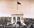
 Ribbon ceremony to open the Sydney Harbour Bridge on 20 March 1932. Breaking protocol, the soon to be dismissed Premier Jack Lang cuts the ribbon while Governor Philip Game looks on. (from History of New South Wales)
 -
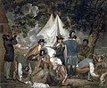 Founding of the settlement of Port Jackson at Botany Bay in New South Wales in 1788 - Thomas Gosse (from History of New South Wales)
 -
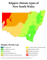 Köppen climate types in New South Wales (from Geography of New South Wales)
 -
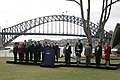 World leaders with Prime Minister John Howard in Sydney for the 2007 APEC conference (from History of New South Wales)
 -
 The Sydney Opera House was opened in 1973. (from History of New South Wales)
 -
 Bondi Beach circa 1900 (from History of New South Wales)


.jpg)


.jpg)


.jpg)


Topics
Categories

More portals
In the news
No recent news
Associated Wikimedia
The following Wikimedia Foundation sister projects provide more on this subject:
-
 Commons
Free media repository -
 Wikibooks
Free textbooks and manuals -
 Wikidata
Free knowledge base -
 Wikinews
Free-content news -
 Wikiquote
Collection of quotations -
 Wikisource
Free-content library -
 Wikiversity
Free learning tools -
 Wikivoyage
Free travel guide -
 Wiktionary
Dictionary and thesaurus


