Sturgeon Weir 205
(Redirected from Sturgeon Landing)
Sturgeon Weir 205 | |
|---|---|
| Sturgeon Weir Indian Reserve No. 205 | |
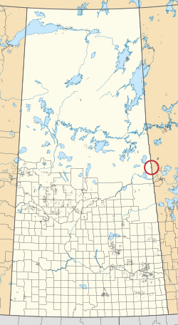
 Location in Saskatchewan | |
| First Nation | Peter Ballantyne |
| Country | Canada |
| Province | Saskatchewan |
| Area | |
| • Total | 26.3 ha (65.0 acres) |
Sturgeon Weir 205 is an Indian reserve of the Peter Ballantyne Cree Nation in Saskatchewan.[1][2] It is adjacent to the east side of Sturgeon Weir 184F. Sturgeon Weir primarily corresponds to the settlement of Sturgeon Landing, located directly next to the Manitoba border at the mouth of the Sturgeon Weir River on Namew Lake. It is accessible by road year round, though only through neighboring Manitoba, via the short Saskatchewan Highway 967 and Sturgeon Landing Road.
See also[edit]
References[edit]
- ^ a b "Reserve/Settlement/Village Detail". Crown–Indigenous Relations and Northern Affairs Canada. Government of Canada. 14 November 2008. Retrieved 12 August 2019.
- ^ "Canada Lands Survey System - CLSS Map Browser". Natural Resources Canada. 13 December 2013. Retrieved 9 October 2019.
54°16′49″N 101°48′56″W / 54.2803°N 101.8155°W

