
Ghukasavan
Ghukasavan
Ղուկասավան | |
|---|---|
 Ghukasavan  Ghukasavan | |
| Coordinates: 40°07′34″N 44°25′04″E / 40.12611°N 44.41778°E | |
| Country | Armenia |
| Province | Ararat |
| Municipality | Masis |
| Population (2008) | |
| • Total | 2,295 |
40°07′34″N 44°25′04″E / 40.12611°N 44.41778°E
Ghukasavan (Armenian: Ղուկասավան) is a village in the Masis Municipality of the Ararat Province of Armenia. It was renamed in 1949 in honor of Ghukas Ghukasian, founder of the Armenian Communist Youth Movement. [1]
History[edit]
The village was founded in the 1600s.[citation needed] The village was settled by Armenians from Western Armenia, survivors of the Armenian genocide from 1915–1917, and later from 1946–1948 by Persian-Armenians. In the 1930s, during the Soviet regime, Yezidi families also settled in the village. It used to have the names Kalal, Kalali, Kolara, Kyalara. Ghukasavan was renamed in 1949. The name is conditioned by the name of revolutionary figure Ghukas Ghukasyan, who was born in this village.
In the center of the village is earthquake destroyed St. Astvatsatsin Church.
The village is located in the Ararat valley, in the valley of the Hrazdan river. It is 845 meters above sea level.
Gallery[edit]
-
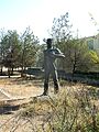 Ghukas Ghukasyan's monument, Ghukasavan
 -
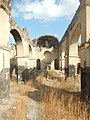 St. Astvatsatsin Church
 -
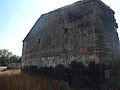 St. Astvatsatsin Church
 -
 St. Astvatsatsin Church
 -
 St. Astvatsatsin Church
 -
 St. Astvatsatsin Church
 -
 St. Astvatsatsin Church
 -
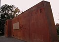
 Monument for WW2
 -
 Monument for WW2
 -
 Monument for WW2
.jpg)
.jpg)
.jpg)
.jpg)
.jpg)
.jpg)
.jpg)
.JPG)
.JPG)
.JPG)
References[edit]
- ^ Kiesling, Rediscovering Armenia, p.24, at the US embassy to Armenia's website Archived June 26, 2008, at the Wayback Machine
External links[edit]
- Ghukasavan at GEOnet Names Server
- World Gazetteer: Armenia[dead link] – World-Gazetteer.com
- Report of the results of the 2001 Armenian Census, Statistical Committee of Armenia

This article about a location in Ararat Province, Armenia is a stub. You can help Wikipedia by expanding it. |