
Portal:Kent/Sandbox
DesktopMobile
Test of: Transclude files as random slideshow/sandbox
-
 The coat of arms of Kent County Council (from Kent)
 -
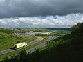
 View of the White Cliffs of Dover from France (from Kent)
 -
-
 Canterbury Cathedral (from Kent)
 -
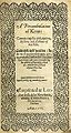 Title page of William Lambarde's Perambulation of Kent (completed in 1570 and published in 1576), a historical description of Kent and the first published county history (from Kent)
 -

-

-

-
-
 Hand-drawn map of Kent, Sussex, Surrey and Middlesex from 1575. (from Kent)
 -
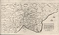 A map of Romney Marsh "The history of imbanking and drayning" by William Dugdale (1662). (from Kent)
 -
 An early mention of Kent in the Anglo-Saxon Chronicle between 11th and 12th centuries (from Kent)
 -
-
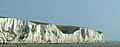 The White Cliffs of Dover (from Kent)
 -
 Geological cross-section of Kent, showing how it relates to major towns (from Kent)


.jpg)
Apr2006.jpg)

Test of: Transclude linked excerpts as random slideshow/sandbox
-
 The University for the Creative Arts is a specialist art and design university in the south of England. (Full article...)
 -
Rochester Cathedral, formally the Cathedral Church of Christ and the Blessed Virgin Mary, is in Rochester, Kent, England. The cathedral is the mother church of the Anglican Diocese of Rochester and seat (cathedra) of the Bishop of Rochester, the second oldest bishopric in England after that of the Archbishop of Canterbury. The cathedral, built in the Norman style is a Grade I listed building. (Full article...)
-
The Weald (/ˈwiːld/) is an area of South East England between the parallel chalk escarpments of the North and the South Downs. It crosses the counties of Hampshire, Surrey, West Sussex, East Sussex, and Kent. It has three parts, the sandstone "High Weald" in the centre, the clay "Low Weald" periphery and the Greensand Ridge, which stretches around the north and west of the Weald and includes its highest points. The Weald once was covered with forest and its name, Old English in origin, signifies "woodland". The term is still used, as scattered farms and villages sometimes refer to the Weald in their names. (Full article...)
-
Dartford is the principal town in the Borough of Dartford, Kent, England. It is located 18 mi (29 km) south-east of Central London and
is situated adjacent to the London Borough of Bexley to its west. To its north, across the Thames estuary, is Thurrock in Essex, which can be reached via the Dartford Crossing. To its east lies the Borough of Gravesham and to the south the district of Sevenoaks. It had a population of 51,240. (Full article...) -
Sussex (/ˈsʌsɪks/; from the Old English Sūþsēaxe; lit. 'South Saxons') is an area within South East England which was historically a kingdom and, later, a county. It includes the ceremonial counties of East Sussex and West Sussex. (Full article...)
-
The Raid on the Medway, during the Second Anglo-Dutch War in June 1667, was a successful attack conducted by the Dutch navy on English warships laid up in the fleet anchorages off Chatham Dockyard and Gillingham in the county of Kent. At the time, the fortress of Upnor Castle and a barrier chain called the "Gillingham Line" were supposed to protect the English ships. (Full article...)
-
Aldington was the stronghold of The Aldington Gang, a band of smugglers roaming the Romney Marshes and shores of Kent. The gang's leaders made the local inn, The Walnut Tree Inn, their headquarters and drop for their contraband. The Inn was often used when they waited for others of their group to bring in goods from across the Marshes. High up on the southern side of the inn is a small window through which the gang would shine a signal light to their partners up on Aldington Knoll when the way was clear for them. (Full article...)
-
The Dungeness nuclear power stations are a pair of non-operational nuclear power stations located on the Dungeness headland in the south of Kent, England. (Full article...)
-
Priestfield Stadium (popularly known simply as Priestfield and officially known from 2007 to 2010 as KRBS Priestfield Stadium and from 2011 as MEMS Priestfield Stadium for sponsorship purposes) is a football stadium in Gillingham, Kent. It has been the home of Gillingham Football Club since the club's formation in 1893, and was also the temporary home of Brighton & Hove Albion Football Club for two seasons during the 1990s. The stadium has also hosted women's and youth international football matches and a London Broncos rugby league match. (Full article...)
-
The London metropolitan area is the metropolitan area of London, England. It has several definitions, including the London Travel to Work Area, and usually consists of the London urban area, settlements that share London's infrastructure, and places from which it is practicable to commute to work in London. It is also known as the London commuter belt, or Southeast metropolitan area. (Full article...)
-
Seven ships of the Royal Navy have been named HMS Africa, after the continent of Africa. Two others were planned:
- HMS Africa (1694) was a 46-gun ship in service from 1694 to 1696.
- HMS Africa (1761) was a 64-gun third-rate launched in 1761 and sold in 1774.
- HMS Africa (1781) was a 64-gun third-rate launched in 1781. She fought at the Battle of Trafalgar and was broken up in 1814.
- HMS Africa was a prison ship, launched in 1803 as the 36-gun fifth rate HMS Euryalus (1803). She became a prison ship in 1826, was renamed HMS Africa in 1859 and was sold in 1860.
- HMS Africa (1862) was a wooden-hulled screw sloop launched in 1862 and sold to China later that year. She was renamed China and was sold in 1865.
- HMS Africa was to have been a Drake-class cruiser but she was renamed HMS Good Hope (1901) in 1899, before being launched in 1901.
- HMS Africa (1905) was a King Edward VII-class battleship launched in 1905 and sold in 1920.
- HMS Africa was to have been an Audacious-class aircraft carrier. She was ordered in 1943, but was later reordered as a Malta-class carrier, before being cancelled in 1945.
- There was also an Irish hired armed cutter Africa, of 7080/94 tons burthen (bm), in Royal Navy service from 12 December 1803 to 12 January 1810.
-
Greenwich (/ˈɡrɛnɪtʃ/ ⓘ GREN-itch, /-ɪdʒ/ -ij, /ˈɡrɪn-/ GRIN-) is a town in south-east London, England, within the ceremonial county of Greater London. It is situated 5.5 miles (8.9 km) east-south-east of Charing Cross. (Full article...)
-
The Kent Police and Crime Commissioner is an elected official tasked with setting out the way crime is tackled by Kent Police in the English County of Kent. The post was created following an election held on 15 November 2012, and replaced the Kent Police Authority. The current incumbent is Matthew Scott, who represents the Conservative Party. (Full article...)
-
Kent is a traditional county in South East England with long-established human occupation. (Full article...)
-
Chalk is a soft, white, porous, sedimentary carbonate rock. It is a form of limestone composed of the mineral calcite and originally formed deep under the sea by the compression of microscopic plankton that had settled to the sea floor. Chalk is common throughout Western Europe, where deposits underlie parts of France, and steep cliffs are often seen where they meet the sea in places such as the Dover cliffs on the Kent coast of the English Channel. (Full article...)
-
Hampshire (/ˈhæmpʃər/, /-ʃɪər/ ⓘ; abbreviated to Hants.) is a ceremonial county in South East England. It is bordered by Berkshire to the north, Surrey and West Sussex to the east, the Isle of Wight across the Solent to the south, Dorset to the west, and Wiltshire to the north-west. The cities of Portsmouth and Southampton are the largest settlements and the county town is the city of Winchester. (Full article...)
-
Beckenham (/ˈbɛkənəm/) is a town in Greater London, England, within the London Borough of Bromley. Prior to 1965, it was part of Kent. It is situated north of Elmers End and Eden Park, east of Penge, south of Lower Sydenham and Bellingham, and west of Bromley and Shortlands, and 8.4 miles (13.5 km) south-east of Charing Cross. Its population at the 2011 Census was 46,844. (Full article...)
-
A brick is a type of construction material used to build walls, pavements and other elements in masonry construction. Properly, the term brick denotes a unit primarily composed of clay, but is now also used informally to denote units made of other materials or other chemically cured construction blocks. Bricks can be joined using mortar, adhesives or by interlocking. Bricks are usually produced at brickworks in numerous classes, types, materials, and sizes which vary with region, and are produced in bulk quantities. (Full article...)
-
Tonbridge (/ˈtʌnbrɪdʒ/ TUN-brij) (historic spelling Tunbridge) is a market town in Kent, England, on the River Medway, 4 miles (6 km) north of Royal Tunbridge Wells, 12 miles (19 km) south west of Maidstone and 29 miles (47 km) south east of London. In the administrative borough of Tonbridge and Malling, it had an estimated population of 41,293 in 2019. (Full article...)
-
Folkestone (/ˈfəʊkstən/ FOHK-stən) is a port town on the English Channel, in Kent, south-east England. The town lies on the southern edge of the North Downs at a valley between two cliffs. It was an important harbour, shipping port and fashionable coastal resort for most part of the 19th and mid 20th centuries. (Full article...)
-
East Sussex is a ceremonial county in South East England. It is bordered by Kent to the north-east, West Sussex to the west, Surrey to the north-west, and the English Channel to the south. The largest settlement is the city of Brighton and Hove, and the county town is Lewes. (Full article...)
-
The Green Party, also known as the Green Party UK, was a Green political party in the United Kingdom. (Full article...)
-
The Kingdom of the Kentish (Old English: Cantwara rīce; Latin: Regnum Cantuariorum), today referred to as the Kingdom of Kent, was an early medieval kingdom in what is now South East England. It existed from either the fifth or the sixth century AD until it was fully absorbed into the Kingdom of Wessex in the late 9th century and later into the Kingdom of England in the early 10th century. (Full article...)
-
Sir Arnold Edward Trevor Bax KCVO (8 November 1883 – 3 October 1953) was an English composer, poet, and author. His prolific output includes songs, choral music, chamber pieces, and solo piano works, but he is best known for his orchestral music. In addition to a series of symphonic poems, he wrote seven symphonies and was for a time widely regarded as the leading British symphonist. (Full article...)
-
Medway is borough and unitary authority area in Kent, South East England. It had a population of 278,016 in 2019. The unitary authority was formed in 1998, when the boroughs of Rochester-upon-Medway and Gillingham were merged to form Medway Towns. The borough is governed by Medway Council, a unitary authority which is independent of Kent County Council, but remains part of the ceremonial county of Kent. (Full article...)
