
User:LukasSimeone/sandbox
SANDBOX
| Wadi Jib | |
|---|---|
 Wadi Jib, a tributary of Wadi Shah, from its confluence with Wadi Arus | |
 | |
| Location | |
| Country | United Arab Emirates |
| Emirate | Ras al-Khaimah |
| Physical characteristics | |
| Source | Southern slope of Jabal ar Rahrah (1,691 m) Al Hajar Mountains |
| • elevation | 1,600 m (5,200 ft) |
| Mouth | Confluence with the Wadi Arus into the Wadi Shah, after the village of Lahsa |
• coordinates | 25°53′58.3″N 56°08′28.2″E / 25.899528°N 56.141167°E |
• elevation | 550 m (1,800 ft) |
| Length | 8 km (5.0 mi) |
| Basin size | 72.06 km2 (27.82 sq mi) |
| Basin features | |
| River system | Wadi Bih (Subbasin Wadi Shah) |
| Tributaries | |
| • left | Wadi Lahsa |
The Wadi Jib [1] is a valley or dry river, with intermittent flow, which flows almost exclusively during the rainy season, belonging to the river basin of Wadi Bih [2] (subbasin of Wadi Shah), north-east of the United Arab Emirates (UAE), in the Emirate of Ras al Khaimah.
It is a tributary of the Wadi Shah,[3] from its confluence with the Wadi Arus,[4] and is formed mainly by the ravines and gullies that run along the southern slopes of the Jabal ar Raḩraḩ (1,691 m.), divided into two large branches; by the deep cliffs located to the west and at the foot of Jabal Sal (1,575 m),[5] on the border line between UAE and Oman; and by multiple ravines that run along the southeast slope of Jabal Rahabah (1,543 m) .
Course[edit]
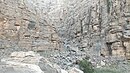
Although, in general, the Wadi Jib flows from north to south, the waters it receives from the east and northeast, from the cliffs that define the border between Oman and UAE, form a set of ravines that are distributed as an alluvial fan, concentrating on a bend that creates the optical illusion that it is a deep and extensive well surrounded by cliffs, forming a wide rounded and flat space, as if it were a large terrace, which retains soil, moisture and water very well, and which quickly turns green again after a rainy season.
This picturesque place, dotted with palm trees and jujubes (jujubas / سدر / Sidr tree - Ziziphus spina-christi, very common in the Al Hajar Mountains), It is known touristically as Hidden Oasis, although locally it is called Sal Shuha.
From this point, the waters coming from the eastern area of Wadi Jib flow westward, concentrated in a single ravine, until they join the branch that descends from the southern slope of Jabal ar Rahrah, to continue later towards the south, receiving the waters of the southeastern slope of Jabal Raḩabah, already in the proximities of the village of Lahsa.
Also in Lahsa, a few meters before its confluence with the Wadi Arus, the Wadi Jib is joined by an important ravine, a tributary on the left, which descends from the surroundings of the town of Musaibat, of which there is no historical toponymic identification, but which is currently called Wadi Lahsa (Wādī Liḩsah).[6]
The Wadi Jib joins the Wadi Arus at approximately the point of coordinates 25°53'58.3"N 56°08'28.2"E, forming the head of the Wadi Shah (Wadi Shehah), which gives its name to the entire hydrographic subbasin.
Toponymy[edit]
Alternative Names: Wadi Jib, Wādī Jib.
The name of Wadi Jib was recorded in the documentation and maps produced between 1950 and 1960 by the British Arabist, cartographer, army officer, and diplomat Julian F. Walker [7] during the work carried out to establish borders between what was then called Trucial States, later completed by the Ministry of Defence (United Kingdom), on 1:100,000 scale maps published in 1971. [8]
There are also references to Wadi Jib, Musaibat and Lahsa, in the detailed studies and publications by the British anthropologist William Lancaster. [9][10]
In the political and administrative organization of the Emirate of Ras al Khaimah, the name of the main wadi is frequently used as an identifying element of the entire territory covered by its drainage basin.
In the case of Wadi Shehah or Wadi Shah, this drainage sub-basin is very large (72.06 km²), comprising numerous towns, villages and farms widely scattered throughout its valleys and mountains. Naturally, it also includes all the ravines and tributaries of the main wadi.
The same denomination is also used for postal purposes.
For this reason, the mistake of considering that this is the only name that corresponds to all the different wadis, and even to some population centers in this region, is widespread, frequently ignoring the true name of each of these places.
This has contributed to the fact that Wadi Jib has also been incorrectly referred to as Wadi Shehah or Wadi Shah on a few occasions.
Population[edit]
The geographical area of Wadi Jib was populated historically by the semi nomadic tribe Shihuh,[11] sections of Bani Hadiyah (Arabic: بني هدية) and Bani Shatair (Arabic: بني شطير), who occupied, among other territories, the tribal areas of Bani Idaid [12] [13] and of Bani Bakhit,[14] respectively.
Gallery[edit]
-
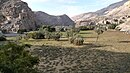
 Wadi Jib, shortly before the village of Lahsa. View of a side ravine
 -
 The ravines of Wadi Jib, located to the east and northeast, form a large bend known to some tourists as the Hidden Oasis
 -
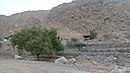 Lahsa Village. On the banks of Wadi Jib, a tributary of Wadi Shah from its confluence with Wadi Arus


See also[edit]
References[edit]
- ^ Mindat.org - Wādī Jib
- ^ Evaluation of the Effect of the Wadi Bih Dam on Groundwater Recharge, UAE - Mohsen Sherif, Abdel Azim Ebraheem, Ampar Shetty, Ahmed Sefelnasr, Khaled Alghafli & Mohamed Al Asam - Natural Disaster Science and Mitigation Engineering: DPRI reports - 2021
- ^ Mindat.org - Wādī Shāh
- ^ Mindat.org - Wādī 'Arūs
- ^ Mindat.org Jabal Sāl
- ^ Jāmiʻat al-Imārāt al-ʻArabīyah al-Muttaḥidah. Geoprojects (U.K.) Ltd., The National Atlas of the United Arab Emirates, Al Ain : United Arab Emirates University - 1993
- ^ FCO 18/1932 - 1958- Sketch map drawn by Julian Walker for boundary delimitation: Ras Al Khaimah - The National Archives, London, England
- ^ FCO 18/1863 - 1971 - Trucial States, Muscat and Oman - Rams - Map. Scale 1:100 000 - Published by D Survey, Ministry of Defence, United Kingdom (1971) - Edition 3-GSGS - The National Archives, London, England
- ^ Lancaster, William; Lancaster, Fidelity (2011). Honour is in contentment : life before oil in Ras al-Khaimah (UAE) and some neighbouring regions. Berlin: De Gruyter. ISBN 978-3-11-022340-8. OCLC 763160662.
{{cite book}}: CS1 maint: date and year (link) - ^ Lancaster, William; Lancaster, Fidelity (13 October 2011). "A discussion of rock carvings in Ra's al Khaimah Emirate, UAE, and Musandam province, Sultanate of Oman, using local considerations". Arabian Archaeology and Epigraphy. 22 (2): 166–195 + 2 Maps. doi:10.1111/j.1600-0471.2011.00338.x. ISSN 0905-7196.
- ^ See, e.g., “Tribal Map of Arabia,” Ordnance Survey 1916, Admiralty War Staff I. D. No. C. B. 1152, Gazetteer of Arabian Tribes (Farnham Common: Archive Editions, 1996), Vol. 18, Map 700.01.
- ^ E F Henderson, Julian F Walker, M S Buckmaster (1958). Tribes of Trucial States coast. Ref. FO 371/132894. The National Archives, London, England.
- ^ Mindat.org - Bani 'Udayd
- ^ Getamap.net - Banī Bakhīt / Ra's al Khaymah
External links[edit]
- Exploring Hidden Oasis In Ras Al Khaimah (YouTube)
- Ras al-Khaimah (RAK) - Hajar Mt- WadiJib - Hidden Oasis - Baighit - Musaibat
![]() Media related to Wadi Jib at Wikimedia Commons
Media related to Wadi Jib at Wikimedia Commons
Category:Rivers of the United Arab Emirates Category:Geography of the Emirate of Ras Al Khaimah