
Wikipedia:Graphics Lab/Map workshop/Archive/Jan 2011
Stale[edit]
Request/Question[edit]
I need help making a map like this one States of Germany. It's similar to imagemap except that it have visible links on it. —Preceding unsigned comment added by XxDestinyxX (talk • contribs) 00:21, 6 November 2010
- Did you have a look at how it is done? Template:Image label also might be of interest to you. bamse (talk) 23:02, 6 November 2010 (UTC)
Philly Neighborhood Map[edit]
-
 General area map
 -


Article(s): List of Philadelphia neighborhoods
Request: I think the above article needs a proper map like this one. Of course, that one is fuzzy and not free so I would like help making one. There are vary user-created Google Maps like this, but not too many others. I think the neighborhood breakdown on the first map is best although here is the gov't list. This page is also a good reference map and much easier to read. Any help making this (preferably SVG) would be great. :) gren グレン 20:35, 1 November 2010 (UTC)
Graphist opinion(s):
![]() Request taken by Wereldburger758 (talk) 20:29, 9 November 2010 (UTC).
Request taken by Wereldburger758 (talk) 20:29, 9 November 2010 (UTC).
- svg-map made of the neighborhoods. Wereldburger758 (talk) 22:20, 9 November 2010 (UTC)
- adding names to the map will be almost impossible other than by making an image map. So what I suggest is making a map exactly like this one. I know it can be done, but I don't know how. I am open to advice from the community. Wereldburger758 (talk) 23:00, 9 November 2010 (UTC)
Locator and street maps for West Philly's Clark Park[edit]
-
 Map of Philadelphia highlighting West Philadelphia

Article(s): Clark Park
Request: For Clark Park in West Philadelphia, please create a locator map using the WPhilaDistrict.PNG map. It would be wonderful as well to have a street map. This map shows the boundary streets, as well as the one that cuts across it; this map shows its location and orientation (but incorrectly omits the bottom triangle). Many thanks! PRRfan (talk) 21:37, 10 November 2010 (UTC)
Graphist opinion:
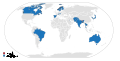
english lang map[edit]
-
 english speaking world
Countries.png)
Article(s): Template:English official language clickable map
Request: Make Somaliland light blue. Outback the koala (talk) 20:26, 14 November 2010 (UTC)
Graphist opinion(s): The English Wikipedia says:"Somaliland (Somali: Jamhuuriyadda Soomaaliland, Arabic: أرض الصومال Arḍ aṣ-Ṣūmāl) is an unrecognized state located in the Horn of Africa. It is regarded internationally as an autonomous region of Somalia." The title of the image is: Anglospeak Countries. Therefore, I won't change the map. Sorry. Regards, Wereldburger758 (talk) 06:06, 15 November 2010 (UTC)
- Would probably need to get consensus on its talk page (or on Anglosphere) for the change. Personally I think this would be an ok change to make - the image title and description say countries, but where it's used in articles the descriptions make a point of using "regions" rather than "countries". If the point is to show the Anglosphere it would make sense to include Somaliland regardless of whether it's recognized, but by that logic other changes should probably be made as well - if using regions and not countries Quebec should probably be switched to light blue. Kmusser (talk) 16:31, 15 November 2010 (UTC)
.svg map combining[edit]


Article(s): To be inserted into National Weather Service Chicago, Illinois and National Weather Service Paducah, Kentucky
Request: Please create county locator maps for Indiana and Illinois combined and Missouri, Illinois, Indiana, and Kentucky combined (leave the highlighting in the resulting maps, if possible). I need them to display the locations of the county warning areas for the Paducah, Kentucky and Chicago, Illinois National Weather Service offices. Also, in the process, could the state borders in the counties highlighted be fixed in a manner similar to that which Kmusser did with this image? Thanks in advance, Ks0stm (T•C•G) 04:34, 23 November 2010 (UTC)
Graphist opinion(s):
Spain Demographic Map[edit]
Article(s): Demographics of Spain
Request: From this website (Ministry of Employment and Immigration, Spain): http://www.mtin.es/es/estadisticas/Inmigracion_emigracion/index.htm you can download the data file 'Inmigración y Emigración (Observatorio Permanente de la Inmigración)' which has Visa and work allowances for immigrants until 2009. The first section gives the total population in 2009 per each listed country. The current article has a map most recently updated in 2002, and lacks to account for the recent EU enlargements (in 2004 and 2007). Please let me know if you have any questions.
The data can be accessed at this link (the first table, you can open with excel). http://extranjeros.mtin.es/es/InformacionEstadistica/Anuarios/ Mdestito (talk) 21:54, 22 November 2010 (UTC)
Graphist opinion(s): Can you provide a more specific link to the data? That would help those of us whose Spanish is a bit rusty... Classical geographer (talk) 15:21, 23 November 2010 (UTC)
The data is here. http://extranjeros.mtin.es/es/InformacionEstadistica/Anuarios/ —Preceding unsigned comment added by Mdestito (talk • contribs) 15:44, 23 November 2010 (UTC)
Resolved[edit]
Angola[edit]
-
 Angola tribes
 -
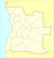 This could help as a base


Article(s): Angola, Demographics of Angola
Request: SVG please :) P. S. Burton (talk) 23:45, 19 November 2010 (UTC)
Graphist opinion(s): ![]() Request taken by jkwchui. This requires manual tracing of some non-trivial shapes and may take some time.
Request taken by jkwchui. This requires manual tracing of some non-trivial shapes and may take some time.
- I've added an SVG map above that could make the task much easier. Regards, -- Orionist ★ talk 11:04, 30 December 2010 (UTC)
 Done Thanks Orionist. This is now complete. Jon C (talk) 18:27, 1 January 2011 (UTC)
- Great. Thank you very much. I did some changes. However, there seems to be some problems with letter-spacing when the file is rendered as a thumb. P. S. Burton (talk) 22:14, 3 January 2011 (UTC)

Empire of Brazil[edit]
-
 Empire of Brazil, c.1825
.svg)
Article(s): Empire of Brazil
Request: Hi, I'd like to see the map with its northwestern boundary exactly like this one [1]. Other maps with the desired border: [2] and [3]. Thank you very much, Lecen (talk) 13:57, 14 December 2010 (UTC)
Graphist opinion(s): The orthographic maps' SVG do not open correctly in Illustrator (something to do with excessive grouping). After fidgeting I could make the corrections but MediawikiSVG no longer recognize the file as valid SVG. I can supply a PNG through a screen capture but a SVG is beyond my tools at the moment. Jon C (talk) 21:49, 28 December 2010 (UTC)
.svg)
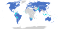
Diplomatic missions of Bangladesh[edit]
-

-
 Updated map


Article(s): List of diplomatic missions of Bangladesh, List of diplomatic missions in Bangladesh
Request: Hi, For the article showing Bangladeshi diplomatic missions worldwide, it already has a map but some changes need to be made on the map. The changes would be Coloring the map of Jordan and Switzerland as Bangladesh has missions in both of those countries. In addition to that, removing the color from the map of Brazil, Senegal, and Nigeria as Bangladesh dont have a diplomatic presence in those countries yet. However, it would be better to color map of Afghanistan, Sudan, and Sierra Leone as bangladesh is establishing embassies in those countries soon. As for the article for diplomatic missions in Bangladesh, it has no map indication. It would be better to show a map of countries which has embassies and honorary consulates present in Bangladesh.
Graphist opinion(s): Diplomatic missions of Bangladesh: map updated to specification, together with the prospective additions (Afg., Sudan, S.L.) Linked to gallery above ![]() Done Jon C (talk) 19:07, 28 December 2010 (UTC)
Done Jon C (talk) 19:07, 28 December 2010 (UTC)
Brazilian presidential election[edit]
-
 First round election image
 -
 Second round map


Article(s): Brazilian presidential election, 2010
Request: We need a 2nd round map "2010 Brazilian presidential election world map - Second round.svg" with data from Brazilian_presidential_election,_2010#Worldwide_results#Second round. Thanks.Lihaas (talk) 16:05, 30 December 2010 (UTC)
Graphist opinion(s):
![]() Done - Fallschirmjäger ✉ 21:02, 6 January 2011 (UTC)
Done - Fallschirmjäger ✉ 21:02, 6 January 2011 (UTC)
List of terrorist incidents[edit]
-
 2009 list
 -
 2010 Map


Article(s): List of terrorist incidents, 2010
Request: Could someone make a map collating data from the aforementioned website to make a map similar the above 2009 one. I know its alot of grunt work, so no rush. Thanks.Lihaas (talk) 16:32, 1 January 2011 (UTC)
Graphist opinion(s):
![]() Done - Fallschirmjäger ✉ 19:18, 5 January 2011 (UTC)
Done - Fallschirmjäger ✉ 19:18, 5 January 2011 (UTC)
New France[edit]

Article(s): Brazil
Request: Fort Toulouse is noted in an incorrect location on the map. It is further to the east, located in present day Wetumpka, AL.
Graphist opinion(s): ![]() Done Jon C (talk) 04:59, 5 January 2011 (UTC)
Done Jon C (talk) 04:59, 5 January 2011 (UTC)
India - Syria realtions[edit]
![]() Request taken by Ciaurlec.
Request taken by Ciaurlec.

Article(s): User:Lihaas/ISR
Request: Need a map to show the locations of India and Syria for the page. (its currently in my sandbox, but ready to go up soon, by which point it will have the page title). Thanks. Lihaas (talk) 18:33, 21 December 2010 (UTC)
- Yes, that would be nice, more in focus.Lihaas (talk) 18:33, 21 December 2010 (UTC)
- That should be good. But can you install it? It doesnt seem to work.Lihaas (talk) 18:33, 21 December 2010 (UTC)
- The page is now installed at India – Syria relationsLihaas (talk) 18:33, 21 December 2010 (UTC)
- never mind, its done
- But can you remove the dutch antilles from this file if possible? File:Indonesia the Netherlands Locator.svg
- dont know if this is possible with the long name but can you decrease the map at Belgium-Congo relations
- France–India relations also needs the terriroties togo as they are incomplete.Lihaas (talk) 18:33, 21 December 2010 (UTC)
- The page is now installed at India – Syria relationsLihaas (talk) 18:33, 21 December 2010 (UTC)
- That should be good. But can you install it? It doesnt seem to work.Lihaas (talk) 18:33, 21 December 2010 (UTC)
- Yes, that would be nice, more in focus.Lihaas (talk) 18:33, 21 December 2010 (UTC)
Graphist opinion(s): Look at proposition in gallery, maybe you will prefere some centered on Asia?
France–Monaco relations[edit]
Article(s): France–Monaco relations
Request: Need a map for the two. For this case eitehr a map of [Western] Europe or France should do (possible an inset of where France is in the world/europe, for the truly stupid;)). Thanks.
- As an aside, can we also have one for France-Italy as ill be working on that soon.Lihaas (talk) 21:03, 27 December 2010 (UTC)
Graphist opinion(s): ![]() Done Modified Monaco to orange per request Jon C (talk) 18:34, 1 January 2011 (UTC)
Done Modified Monaco to orange per request Jon C (talk) 18:34, 1 January 2011 (UTC)


Foreign relations of Bhutan[edit]
-
 Countries with Diplomatic relations with Bhutan
 -
 Updated version


Article(s): Foreign relations of Bhutan
Request: Can someone color, Brazil, Belgium and Afghanistan in green? Spongie555 (talk) 04:48, 28 December 2010 (UTC)
- can we delete the old one? (Lihaas (talk) 16:10, 30 December 2010 (UTC));
- You can if you want. Spongie555 (talk) 06:36, 2 January 2011 (UTC)
Graphist opinion(s): ![]() Done and also redrawn in SVG. See gallery above. Jon C (talk) 22:08, 28 December 2010 (UTC)
Done and also redrawn in SVG. See gallery above. Jon C (talk) 22:08, 28 December 2010 (UTC)
Geographic coordinates on a map[edit]

This is not really a graphics request, but I'm placing it here since I don't know of a better place (suggestions welcome). I would like to find a way to transform geographical coordinates (i.e., longitude and latitude) into map coordinates on File:Madagascar range map template.svg. The approach I'm taking now is placing a marker at an easily recognizable location on the map, getting its map coordinates from the SVG text, getting the location's coordinates on Google Maps or so, and working out the formula. However, there may be other, better ways. Ucucha 10:22, 5 January 2011 (UTC)
- Do you mean Template:location_map? Uwe Dedering (talk) 17:14, 5 January 2011 (UTC)
- That is similar, yes, but not quite as useful, because it does not create a new image. I've put together the program by now; see User:Ucucha/Mapper. Ucucha 21:07, 6 January 2011 (UTC)
1 country to a map?[edit]
-
 Present states parties image
 -


Article(s): Apostille treaty
Request: I found this image on commons. It looks good for the article, but Mongolia is missing. (see members here). Could that be added? L.tak (talk) 22:30, 15 January 2011 (UTC)
Graphist opinion(s):
![]() Done: That map is missing quite a few countries, plus Mongolia isn't a fully recognized member. I've created a new map according to the official list from the link you provided. Fallschirmjäger ✉ 14:24, 16 January 2011 (UTC)
Done: That map is missing quite a few countries, plus Mongolia isn't a fully recognized member. I've created a new map according to the official list from the link you provided. Fallschirmjäger ✉ 14:24, 16 January 2011 (UTC)
- thanks, that looks much better; I like the distinction between member states and non member states to the organization as well. My only comment is China, where it is only applied to the SARs Macao and Hong Kong.. (see here); could you change that? L.tak (talk) 14:46, 16 January 2011 (UTC)
- Redone - No problem, China changed now to only show SARs. Regards, Fallschirmjäger ✉ 15:52, 16 January 2011 (UTC)
Puerto Rico Map Topographic[edit]
-
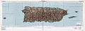 1952 Topographic map of the archipelago of Puerto Rico
Request: Needs center line removed. QuAzGaA 02:05, 11 December 2010 (UTC)
Graphist opinion(s): Try the photography workshop -- there are better experts in blending out raster images than here. Jon C (talk) 07:28, 3 January 2011 (UTC)
Eyak native tribe[edit]
-
 Map showing Ahtna language. Eyak is #15
 -
-
 Eyak highlighted, (Ahtna is now #15).


![[1]](https://upload.wikimedia.org/wikipedia/commons/archive/1/12/20101218145055%21Empire_of_brazil_frontiers_1889.png)
![[2]](https://en.wikipedia.org/wiki/File:Empire_of_brazil_frontiers_1889.png)
![[3]](https://en.wikipedia.org/wiki/File:Brazil_provinces_1825.PNG)
Article(s): Eyak language, Eyak
Request: Looking for a location map for the Eyak language. Vedrfolnir (talk) 22:38, 10 December 2010 (UTC)
Graphist opinion(s):
![]() Done: Is this OK? P. S. Burton (talk) 20:56, 23 January 2011 (UTC)
Done: Is this OK? P. S. Burton (talk) 20:56, 23 January 2011 (UTC)