
Wikipedia:Graphics Lab/Map workshop/Archive/Oct 2022
| This page is an archive. Do not edit the contents of this page. Please direct any additional comments to the current main page. |

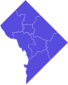
Request: 2022 District of Columbia Mayoral Election, results by ward
-
 Reference image from 2018 election.
 -
 Result


- Article
- 2022 Washington, D.C., mayoral election
- Request
- Hello, I was wondering if someone could make a map of the 8 wards of DC colored according to the election results of the 2022 mayoral election. For example, a darker shade of blue if the Democratic candidate won 80-90% of the vote and a lighter shade of blue if she won 70-80% of the vote. The results can be found here. DC's ward boundaries were updated after the 2020 census, so please make sure to use the updated boundaries, which can be found here. Thank you. — Preceding unsigned comment added by Aidanlang (talk • contribs)
- Discussion
Aidanlang ![]() Done File:District of Columbia mayoral election results by ward, 2022.svg – Berrely • T∕C 20:14, 12 November 2022 (UTC)
Done File:District of Columbia mayoral election results by ward, 2022.svg – Berrely • T∕C 20:14, 12 November 2022 (UTC)
- Thank you for taking the time to make this, but I think you used the results from the Delegate election and not the mayoral election. Aidanlang (talk) 20:57, 12 November 2022 (UTC)
Basutoland during the Mfecane
- Article(s)
- History of Lesotho
- Moshoeshoe I
- Request
- Create a copy of this map which was taken from *J.D. Omer-Cooper, The Zulu Aftermath: A Nineteenth-Century Revolution in Bantu Africa, Longmans, 1978: ISBN 0-582-64531-X - page 100.--Catlemur (talk) 18:56, 3 October 2022 (UTC)
- Discussion
Oregon Ballot Measure 112 Map
- Article(s)
- Oregon Ballot Measure 112
- Request
- Hi i am just wondering can sombody make a Map of the results from the Oregon Ballot Measure 112,
Here is a source.[1] Thanks. La lopi (talk) 06:25, 17 November 2022 (UTC)
- Discussion
@La lopi: ![]() Done, it's been added to the article. —twotwofourtysix(talk || edits) 01:58, 22 November 2022 (UTC)
@Twotwofourtysix: , Thanks for doing that. La lopi (talk) 09:16, 22 November 2022 (UTC)
{{resolved}}
Done, it's been added to the article. —twotwofourtysix(talk || edits) 01:58, 22 November 2022 (UTC)
@Twotwofourtysix: , Thanks for doing that. La lopi (talk) 09:16, 22 November 2022 (UTC)
{{resolved}}
Dhofari Arabic Map
-
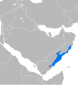 Old unsourced inaccurate map
 -
 New sourced map23: Dhofari Arabic
 -
 Finished map


- Article(s)
- Dhofari_Arabic
- Request
- @M.Bitton suggested here to draw a new map to replace the old one which is inaccurate (sources don't report Dhofari as being spoken in Yemen). The source of the new map is Ethnologue and especially their map of Oman. However, the new map isn't specifically centered on Dhofari Arabic, a new centered map would be better. -- A455bcd9 (talk) 12:53, 22 November 2022 (UTC)
- Discussion
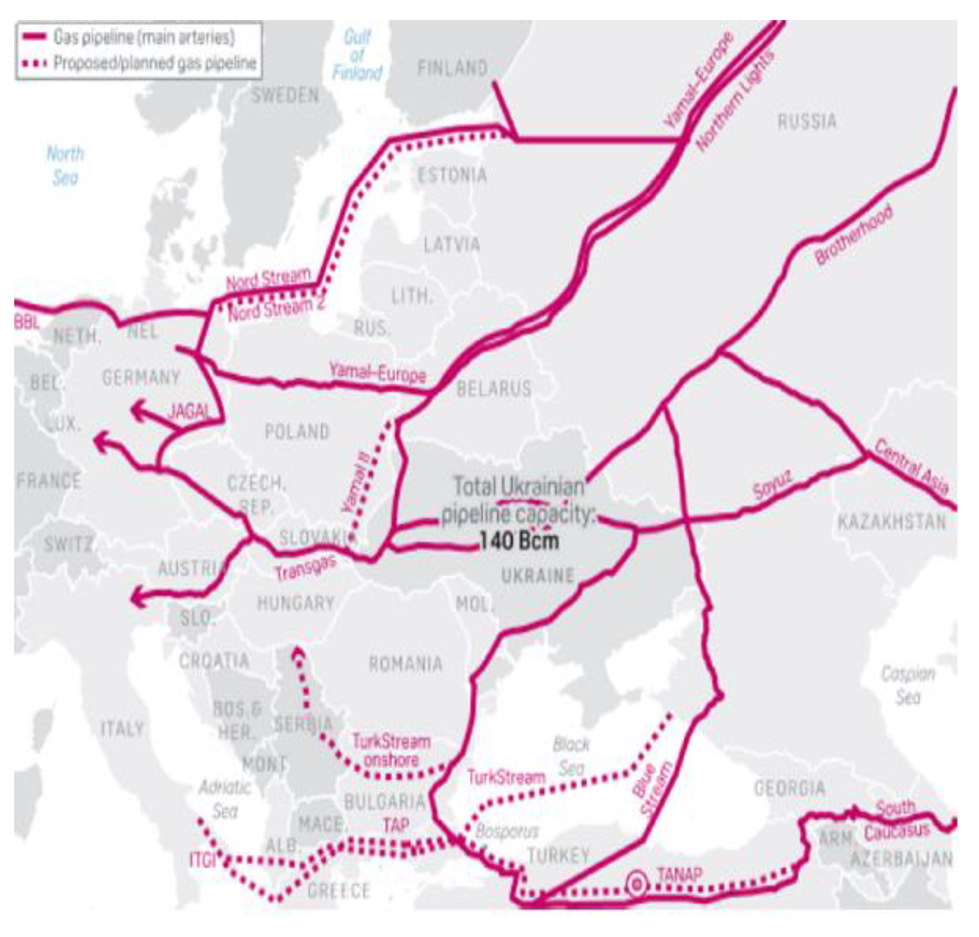
Gas pipelines in Turkey
- Article(s)
- Oil and gas in Turkey
- Request
- At https://en.wikipedia.org/wiki/Wikipedia:Graphics_Lab/Map_workshop/Archive/Jun_2022#Oil_and_Gas_in_Turkey berrely kindly made the above draft. But the request stalled - perhaps I asked for too many pernicketty small changes. As the draft looks much more professional than my scrawled map that is in the article at the moment I don't want to make the perfect the enemy of the good.
So as you guys are no doubt busy could just the 4 most important changes be done for a svg version:
1) In unobtrusive (maybe small grey) text show "Source: https://enerji.gov.tr/bilgi-merkezi-haritalar" which is a map I recently found on the Energy Ministry website.
2) Correct the pipeline from Tabriz as I am 100% sure it does not pass through Armenia (exact route through Turkey and Iran not important - a straight line would be fine).
3) Extend Turkstream to cross the border to Greece (if you have to remove the LNG plant it is ok as less important).
4) Move Sakarya/Tuna 1 red blob down slightly to show it separate from Turkstream (otherwise readers might think they are connected).
-- Chidgk1 (talk) 09:30, 19 September 2022 (UTC)
- Discussion
- Hi @Chidgk1 my apologies, I completely forgot about this. I'm a bit busy recently but I'll try and have a ook in completing this. If anyone else wants to have a go I'm happy to send the ArcGIS file or PDF. – Berrely • T∕C 12:28, 19 September 2022 (UTC)
- Not sure this is helpful, but this map is available under the CC BY license ("All articles published by MDPI are made immediately available worldwide under an open access license. No special permission is required to reuse all or part of the article published by MDPI, including figures and tables. For articles published under an open access Creative Common CC BY license, any part of the article may be reused without permission provided that the original article is clearly cited."): https://www.mdpi.com/1996-1073/14/12/3595/htm# A455bcd9 (talk) 13:12, 19 September 2022 (UTC)
- Thanks. I am still working on the text of the article to get ready for the "good article review". I just noticed on my rubbish map I have mixed up Iraq and Iran! Chidgk1 (talk) 14:45, 19 September 2022 (UTC)
- Berrely I hope you are well. I don't want to take up your time but I don't want your valuable work so far to be wasted either. So could you possibly upload it as an svg as it is now and I will attempt to edit it myself (don't know Inkscape very well but will have a shot). Chidgk1 (talk) 07:57, 10 October 2022 (UTC)
- @Chidgk1 I've done all your suggestions other than the last one which I'll do later. I'll also add arrows for the pipelines extending into Greece. Apologies for how long it's taken me on this: https://i.imgur.com/0Rr8ry7.png Please feel free to suggest any other changes. – Berrely • T∕C 17:20, 11 October 2022 (UTC)
- Berrely No probs about time - I am still working slowly on the article text getting ready for a "good article" reviewer - I think that is great - no more changes needed at present as I would not be surprised if the politics changes soon anyway - who knows what country Mr P will cut off next - so if you could upload an svg as it is now that would be really useful.
- I will probably put in a request for an oil pipelines map using this as an example - so in the svg will the layer containing the common stuff like city names be separate from the pipeline names and routes so whoever takes on the oil map on can easily clone it and swap gas for oil? Chidgk1 (talk) 11:39, 12 October 2022 (UTC)
- @Chidgk1 I've done all your suggestions other than the last one which I'll do later. I'll also add arrows for the pipelines extending into Greece. Apologies for how long it's taken me on this: https://i.imgur.com/0Rr8ry7.png Please feel free to suggest any other changes. – Berrely • T∕C 17:20, 11 October 2022 (UTC)
- Berrely I hope you are well. I don't want to take up your time but I don't want your valuable work so far to be wasted either. So could you possibly upload it as an svg as it is now and I will attempt to edit it myself (don't know Inkscape very well but will have a shot). Chidgk1 (talk) 07:57, 10 October 2022 (UTC)
Version of map with better colors
-
 Original map

- Article(s)
- al-Muti, Iranian Intermezzo, etc.
- Request
- Can someone please make a version of the map that has colors suitable to colorblind readers? And while we are at it, make it into an svg format? Constantine ✍ 07:25, 26 October 2022 (UTC)
- Discussion
The problem came up at the FAC for al-Muti: the colors used are not clearly discernible for colorblind people. It is also a good opportunity to have the map as svg rather than png. The original map author, Ro4444, unfortunately has not contributed to Wikipedia in two years. Constantine ✍ 07:25, 26 October 2022 (UTC)
![]() Request taken by --always ping me-- Goran tek-en (talk) 16:12, 9 November 2022 (UTC).
Request taken by --always ping me-- Goran tek-en (talk) 16:12, 9 November 2022 (UTC).
- Cplakidas I will need your help in this and I will get back to you with drafts. --always ping me-- Goran tek-en (talk) 16:12, 9 November 2022 (UTC)
- @Cplakidas First I need you to tell me if this is the area you want the map to cover, map area? --always ping me-- Goran tek-en (talk) 16:50, 9 November 2022 (UTC)
- @Goran tek-en: thanks for taking this on. The area in the map above is slightly larger than the original map, but substantially, yes. Constantine ✍ 17:01, 9 November 2022 (UTC)
- @Cplakidas Yes I know so I will cut down a bit. The source map has topographic features, do you want that? --always ping me-- Goran tek-en (talk) 17:21, 9 November 2022 (UTC)
- @Goran tek-en: hmmm, let's stay close to the original, so yes. Constantine ✍ 17:45, 9 November 2022 (UTC)
- @Cplakidas
- ----
- This draft is a PNG version of the original SVG file I'm working in and will upload to commons.
- This draft is shown for proofreading only.
- ----
- Combining different maps is always difficult due to different projections and how they were created. Here we also have today coastlines, lakes, rivers, wadis and ephermal combined with the source map which is hard to view.
- So before I continue I need you to check this draft-waters and give me feedback, thanks.
- Don't think about how visible things are, will work with that later, right now it's about getting the information we want to be included and in the right place. --always ping me-- Goran tek-en (talk) 12:42, 12 November 2022 (UTC)
- @Goran tek-en: Well, wadis and ephemeral waters are not necessary, and modern reservoirs etc. are obviously ahistorical. Coasts, lakes, major rivers are enough I'd say. Constantine ✍ 14:49, 12 November 2022 (UTC)
- @Cplakidas You did say before you wanted this new to be "close to the original" so I added all waters from it. So we will later on decide what you mean by "major rivers" but it would be very helpful for me if there is other stuff in the source map you don't think is necessary so I don't have to do work not going to be used, thanks. --always ping me-- Goran tek-en (talk) 15:01, 12 November 2022 (UTC)
- @Goran tek-en: you are right, apologies if I inadvertently misled you. It's just that many of the waters shown in modern maps are incorrect for a tenth-century map. Most prominently, modern reservoirs created by dams. But as this may be a difficult exercise to determine, and is not the point of this request, let's say that the draft above is fine and thus there are no unnecessary parts in the original. Since the new map will be in svg, I can do some small minor fixes afterwards if necessary. Constantine ✍ 12:18, 13 November 2022 (UTC)
- @Cplakidas All that's in this draft (and the ones to follow) is a part of the original source map (I edited that one to be able to see all the waters), I haven't added anything from today's maps which doesn't appear in the source map. --always ping me-- Goran tek-en (talk) 13:53, 13 November 2022 (UTC)
- @Goran tek-en: you are right, apologies if I inadvertently misled you. It's just that many of the waters shown in modern maps are incorrect for a tenth-century map. Most prominently, modern reservoirs created by dams. But as this may be a difficult exercise to determine, and is not the point of this request, let's say that the draft above is fine and thus there are no unnecessary parts in the original. Since the new map will be in svg, I can do some small minor fixes afterwards if necessary. Constantine ✍ 12:18, 13 November 2022 (UTC)
- @Cplakidas You did say before you wanted this new to be "close to the original" so I added all waters from it. So we will later on decide what you mean by "major rivers" but it would be very helpful for me if there is other stuff in the source map you don't think is necessary so I don't have to do work not going to be used, thanks. --always ping me-- Goran tek-en (talk) 15:01, 12 November 2022 (UTC)
- @Goran tek-en: Well, wadis and ephemeral waters are not necessary, and modern reservoirs etc. are obviously ahistorical. Coasts, lakes, major rivers are enough I'd say. Constantine ✍ 14:49, 12 November 2022 (UTC)
- @Goran tek-en: hmmm, let's stay close to the original, so yes. Constantine ✍ 17:45, 9 November 2022 (UTC)
- @Cplakidas Yes I know so I will cut down a bit. The source map has topographic features, do you want that? --always ping me-- Goran tek-en (talk) 17:21, 9 November 2022 (UTC)
- @Goran tek-en: thanks for taking this on. The area in the map above is slightly larger than the original map, but substantially, yes. Constantine ✍ 17:01, 9 November 2022 (UTC)
- @Cplakidas First I need you to tell me if this is the area you want the map to cover, map area? --always ping me-- Goran tek-en (talk) 16:50, 9 November 2022 (UTC)
@Goran tek-en: the original map relies on the same GIS data as yours, I guess, so it is equally ahistorical. Don't worry about this, the minor hydrographic features are not that important. Constantine ✍ 13:57, 13 November 2022 (UTC)
- Cplakidas
- I do think there is some differences between the maps, Aral lake is much bigger on the source map and the coastline is different in some places so I used the source map there.
- On this draft I need help with the different areas labeled as Sovereign states mostly.
- Do not think about placing or visibility of the texts I will fix that later.
- I have hard to understand which areas, names and borders belong to which of the different levels: Sovereign, vassal subsidiary, tribe, province. If you could list them here it would help me a lot, thanks.
- Which areas is covered by each of Kievan Rus, Alans, Khazars, I can't find any borders between them.
- Qarmathians, is that the whole of the grey area?
- Between Saffarid Amirate and Samanid Amirate, where should the border go, it's covered by the legend so I can't see.
- Just below Dvin city there is a city I can't find the name for, I marked it with X. --always ping me-- Goran tek-en (talk) 19:11, 16 November 2022 (UTC)
- @Cplakidas: I don't want to rush you but I need your help as above to be able to continue with your request, thanks. --always ping me-- Goran tek-en (talk) 12:06, 19 November 2022 (UTC)
- @Goran tek-en: Sorry, during the week I am sometimes busy and can't respond quickly. On your questions:
- Not necessary to find fixed borders for them; a) they are not the subject of the map, but peripheral to it, and b) precise borders didn't really exist for these, as they were tribes more than territorial states.
- Ditto, just place the label on the eastern Arabian coast
- At this time, the Saffarids ruled only Sistan, so the border should pass over Bust in File:Iran circa 1000AD.png and then curve back south
- The city is Goghtn.
- Some additional fixes to the draft: 'Hamdanid' not 'Hamidanid', 'Sebasteia' not 'Sebastia', 'Trebizond' not 'Trabzon', 'Qarmatians' not 'Qarmathians'
- Cheers, Constantine ✍ 13:19, 19 November 2022 (UTC)
- @Cplakidas I just wanted to make sure you had seen this, good to know when you can reply. Thanks for the info. --always ping me-- Goran tek-en (talk) 14:03, 19 November 2022 (UTC)
- No worries. I will always reply, but it may take a few days. Constantine ✍ 14:16, 19 November 2022 (UTC)
- @Cplakidas Please always ping me, thanks.
- To my understanding there are four levels of areas;
- 1 state
- 2 vassal or ..
- 3 tribe
- 4 province
- and those different areas should have names formatted in four different ways.
- But to me the map is not consistent so you have to help me here.
- A Is Georgia, Tiflis, Golt'n ... states with borders?
- B Is Khuttal, Simjurids ... vassal or .. without borders?
- C Is Alans, Khazars ... tribes without borders?
- D Is Syria, Gilan, Gurgan ... provinces without borders?
- 5 What is Kievan Rus?
- 6 Can't see a border between K of Armenia and Vaspurakan or is it not states? --always ping me-- Goran tek-en (talk) 15:24, 19 November 2022 (UTC)
- @Goran tek-en: in principle, italics denote tribes, all other underlined entities, especially if they have boundaries, are states. Specifically to your questions: Georgia, Tiflis, Golt'n are states with borders. Khuttal is a vassal principality, and the Simjurids vassal dynasty, both under the Samanids. Alans and Khazars were tribes, and their borders rang from speculative to unknown; as pointed out above, we can ignore them here. Syria I would actually place inside the Fatimid domains, as the bulk of the province was under their control. Alternatively we could substitute it altogether with the junds of Medieval Syria, as shown in File:Syria_in_the_9th_century.svg. Gilan and Gurgan are provinces without borders. Kievan Rus is early medieval Russia, it is a state, but its borders do not concern us here, as the area labelled with them was under their loose control and their exact borders in the south are unknown either way. Constantine ✍ 16:11, 20 November 2022 (UTC)
- @Cplakidas Can't see a border between K of Armenia and Vaspurakan?
- Draft to be checked --always ping me-- Goran tek-en (talk) 19:13, 20 November 2022 (UTC)
- @Goran tek-en: You can use this as reference: File:Bagratid Armenia, 962-1064.gif. On the draft, the colors should not suggest that the Buyid amirates were not Muslim states as well. Their color should still be close enough to the other Muslim states. Constantine ✍ 19:51, 20 November 2022 (UTC)
- @Cplakidas I don't understand at all, I have followed your source Buyids within the Middle East, ca. 970 and now you are talking about more than 3 different colored areas. You will have to explain because I don't understand. --always ping me-- Goran tek-en (talk) 21:27, 20 November 2022 (UTC)
- @Goran tek-en: The source map used two shades of blue, one for the Buyids, and one for the other Muslim states. This is because the Buyids were also Muslims. In the draft, the referse is true: the Buyids are in a shade of red, then the mistaken assumption might be made that they were Christian states. We should be careful, both in the coloring and the labelling, not to suggest that 'Muslim state' excludes the 'Buyid amirates'. I would suggest, at the very least, changing the labelling from 'Muslim state' to 'Other Muslim states' (and correspondingly 'Christian state' to 'Christian states'), but if possible, the color for the Buyids should be close to that for the other Muslim states. Constantine ✍ 21:33, 20 November 2022 (UTC)
- @Cplakidas I have zero knowledge of those things so you have to tell me what to write etc. One disadvantage with the old map was just this with two colors to close so when I create a map I always try as much as possible to make them work for as many people as possible, also with color deficiency. So here are two different drafts;
- colors
- stripes
- Besides the versions you also have to check everything. The File:Bagratid Armenia, 962-1064.gif had very different borders so you really have to check the border I guessed for K of Armenia and Vaspurakan, thanks. --always ping me-- Goran tek-en (talk) 12:50, 21 November 2022 (UTC)
- @Goran tek-en: Noted. On the colors, I think I prefer the solid-colored one; the striped one is frankly difficult for me to discern. On the borders, don't worry overmuch if they are somewhat iffy: these are medieval states, where the exact border course is unknown, and even then there was more of a border zone, rather than a specific line on the map. AFAICT, the map looks fine. Only a typo, 'Abu Da'udids', and I guess the unlabeled state above the Hamdanids ('nominally to Hamdanids' in the original) are the Kaysites, whom I would add. Constantine ✍ 18:14, 21 November 2022 (UTC)
- @Cplakidas New draft. --always ping me-- Goran tek-en (talk) 13:00, 22 November 2022 (UTC)
- @Cplakidas I do understand that you are busy with other things but I can't continue without your feedback on the draft as above.
- Eventualli I will need the following;
- Name of the file
- Description (/language)
- Captions/s (/language)
- Category/ies at commons
- Structured data/Items portrayed in this file, the Q#, to be able to upload it at commons, thanks.
- --always ping me-- Goran tek-en (talk) 13:31, 26 November 2022 (UTC)
- @Cplakidas New draft. --always ping me-- Goran tek-en (talk) 13:00, 22 November 2022 (UTC)
- @Goran tek-en: Noted. On the colors, I think I prefer the solid-colored one; the striped one is frankly difficult for me to discern. On the borders, don't worry overmuch if they are somewhat iffy: these are medieval states, where the exact border course is unknown, and even then there was more of a border zone, rather than a specific line on the map. AFAICT, the map looks fine. Only a typo, 'Abu Da'udids', and I guess the unlabeled state above the Hamdanids ('nominally to Hamdanids' in the original) are the Kaysites, whom I would add. Constantine ✍ 18:14, 21 November 2022 (UTC)
- @Goran tek-en: The source map used two shades of blue, one for the Buyids, and one for the other Muslim states. This is because the Buyids were also Muslims. In the draft, the referse is true: the Buyids are in a shade of red, then the mistaken assumption might be made that they were Christian states. We should be careful, both in the coloring and the labelling, not to suggest that 'Muslim state' excludes the 'Buyid amirates'. I would suggest, at the very least, changing the labelling from 'Muslim state' to 'Other Muslim states' (and correspondingly 'Christian state' to 'Christian states'), but if possible, the color for the Buyids should be close to that for the other Muslim states. Constantine ✍ 21:33, 20 November 2022 (UTC)
- @Cplakidas I don't understand at all, I have followed your source Buyids within the Middle East, ca. 970 and now you are talking about more than 3 different colored areas. You will have to explain because I don't understand. --always ping me-- Goran tek-en (talk) 21:27, 20 November 2022 (UTC)
- @Goran tek-en: You can use this as reference: File:Bagratid Armenia, 962-1064.gif. On the draft, the colors should not suggest that the Buyid amirates were not Muslim states as well. Their color should still be close enough to the other Muslim states. Constantine ✍ 19:51, 20 November 2022 (UTC)
- @Goran tek-en: in principle, italics denote tribes, all other underlined entities, especially if they have boundaries, are states. Specifically to your questions: Georgia, Tiflis, Golt'n are states with borders. Khuttal is a vassal principality, and the Simjurids vassal dynasty, both under the Samanids. Alans and Khazars were tribes, and their borders rang from speculative to unknown; as pointed out above, we can ignore them here. Syria I would actually place inside the Fatimid domains, as the bulk of the province was under their control. Alternatively we could substitute it altogether with the junds of Medieval Syria, as shown in File:Syria_in_the_9th_century.svg. Gilan and Gurgan are provinces without borders. Kievan Rus is early medieval Russia, it is a state, but its borders do not concern us here, as the area labelled with them was under their loose control and their exact borders in the south are unknown either way. Constantine ✍ 16:11, 20 November 2022 (UTC)
- No worries. I will always reply, but it may take a few days. Constantine ✍ 14:16, 19 November 2022 (UTC)
- @Cplakidas I just wanted to make sure you had seen this, good to know when you can reply. Thanks for the info. --always ping me-- Goran tek-en (talk) 14:03, 19 November 2022 (UTC)
- @Goran tek-en: Sorry, during the week I am sometimes busy and can't respond quickly. On your questions:
- @Cplakidas: I don't want to rush you but I need your help as above to be able to continue with your request, thanks. --always ping me-- Goran tek-en (talk) 12:06, 19 November 2022 (UTC)
@Goran tek-en: As far as I can tell, the latest draft looks good. One suggestion only: in the legend, move the Buyids first, as they are the main subject of the map, and so that 'Other Muslim states' is placed in context. On the rest:
- For filename, I would suggest 'Buyid amirates in the Middle East, ca. 970.svg' which is close to the original but not identical.
- English description should be close to the original, something like 'The domains of the Buyid dynasty (light green?), highlighted among other Muslim (green) and eastern Christian (pink) states, ca. 970 CE', with a notice that this is is a vectorization of the original file.
- Categories can be the same as in the original file.
- Captions etc. I can add myself when the map is up.
Thank you for your time and skills, and a really amazing map! Constantine ✍ 11:18, 27 November 2022 (UTC)
- @Cplakidas Now you can find it here Commons:file:Buyid amirates in the Middle East, ca. 970.svg.
- I have added the colors in the description but as they are transparent to some degree they are not really just one color in the map but this is the closest I can get. If you don't want it we can just remove them.
- Please check all the information, also links for wikipedia, wikidata and structured data.
- If you are happy with this please put the code
{{re.solved|~~~~}}(without the ".") on this request so it can be archived, thanks. Done
Done
- --always ping me-- Goran tek-en (talk) 15:55, 28 November 2022 (UTC)
- @Goran tek-en: It looks great! Thanks again! Constantine ✍ 18:17, 29 November 2022 (UTC)
- {{resolved}}
Map of Cuban Municipalities
-
 Map of municipalities of Cuba
 -
 Location map of Cuba showing the provinces and the municipalities
 -
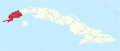 Map showing a province (Pinar del Río Province)
 -
 Map showing a municipality (Quivicán)

.svg)
.svg)
.svg)
- Article(s)
- Municipalities of Cuba
- Request
- This map is wrong in alot of ways, first where im from Camajuani is undetailed, just 9 lines make it up. Looking at Havana it is way to big. It's a good map to show basic location, not for actual borders. A good source is OSM but then you'll have to go type each municipality so here is the same map but it includes all of the borders of the municipalities. https://www.citypopulation.de/en/cuba/admin/. Thank you! CubanoBoi (talk) 19:21, 5 October 2022 (UTC)
- Discussion
 Request taken by M.Bitton (talk) 19:29, 5 October 2022 (UTC).
- @CubanoBoi: please have a look at these major deviations from the current map and let me know whether they look correct to you: on the citypopulation map, Caibarien is split into two parts by Remedios (which stretches all the way to the coast), Nuevitas is about 30% bigger (at the expense of Guaimaro), while Manuel Tames is about 50% bigger (at the expense of Guantanamo). M.Bitton (talk) 16:07, 8 October 2022 (UTC)
- @M.Bitton: it’s correct, google “mapa de ____” and go in images, if there’s a map on any “.gob.cu” website then that map is correct. As you can see here https://www.ipf.gob.cu/es/content/m-caibarién caibarién is correct CubanoBoi (talk) 16:21, 8 October 2022 (UTC)
- @CubanoBoi: I wish I'd known about that site sooner. Anyway, I compared some random provinces and municipalities with their maps and they all appear to be correct. Something else: if you zoom on the islands off the coast of Santa Cruz del Sur, you'll notice that the ones on the left are not highlighted in green. Is there a reason for that? M.Bitton (talk) 17:16, 8 October 2022 (UTC)
- @M.Bitton: most likely a mistake, prolly part of Santa Cruz del Sur CubanoBoi (talk) 18:19, 8 October 2022 (UTC)
- @CubanoBoi: What about the U.S. naval base? I can omit it from the map (which seems to be the case for most maps of Cuba on WP) or show it (like they do on their website). Incidentally, in the citypopulation's map, the enclosed Guantanamo bay (north of the base) appears to be missing. M.Bitton (talk) 17:55, 10 October 2022 (UTC)
- @M.Bitton: most likely a mistake, prolly part of Santa Cruz del Sur CubanoBoi (talk) 18:19, 8 October 2022 (UTC)
- @CubanoBoi: I wish I'd known about that site sooner. Anyway, I compared some random provinces and municipalities with their maps and they all appear to be correct. Something else: if you zoom on the islands off the coast of Santa Cruz del Sur, you'll notice that the ones on the left are not highlighted in green. Is there a reason for that? M.Bitton (talk) 17:16, 8 October 2022 (UTC)
- @M.Bitton: it’s correct, google “mapa de ____” and go in images, if there’s a map on any “.gob.cu” website then that map is correct. As you can see here https://www.ipf.gob.cu/es/content/m-caibarién caibarién is correct CubanoBoi (talk) 16:21, 8 October 2022 (UTC)
- Done @CubanoBoi: Have a look at the maps and let me know what you think. M.Bitton (talk) 00:02, 18 October 2022 (UTC)
- @M.Bitton AMAZING, THANK YOU SO MUCH CubanoBoi (talk) 01:29, 18 October 2022 (UTC)
- @M.Bitton I see that you used a text editor, can I use inkscape to shade in the rest of the municipalities? CubanoBoi (talk) 01:35, 18 October 2022 (UTC)
- @CubanoBoi: Thanks. Actually, using Inkscape would defeat the purpose of having this particular map (used to generate and update all the related maps very quickly). The maps are ready, but I could do with some help with uploading all 175 of them. If you want, I can come up with a way that will allow both of us to upload them at our own leisure. M.Bitton (talk) 23:23, 19 October 2022 (UTC)
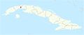
Request: SVG locator map for English-speaking countries
-
 current PNG map
 -
 replacement SVG map
 -
 New map
Countries.png)


- Article(s)
- Template:English official language clickable map
- Request
- Could the SVG map be modified to fit the template (should at least be cropped), or the template be modified to fit the SVG, so that the PNG can be replaced? Thanks -- — kwami (talk) 22:33, 14 February 2022 (UTC)
- Discussion
- @Kwamikagami Done — Berrely • Talk∕Contribs 17:59, 15 February 2022 (UTC)
- Thanks, the cropping's good, but it still doesn't fit the template. Do we need to manually adjust the encoding for the links, or is there an easier way to address this? — kwami (talk) 22:59, 15 February 2022 (UTC)
- {@Kwamikagami: What's the point of replacing a map that isn't meant to be expanded? Also, why modify an SVG map to fit the template and not simply add the hyperlinks to the SVG? M.Bitton (talk) 23:37, 15 February 2022 (UTC)
- That's why I said "or the template be modified to fit the SVG." You guys know how these things work, not me. — kwami (talk) 01:45, 16 February 2022 (UTC)
- First things first. Let's start by identifying the issues with the current map and then we'll take it from there. Is there a particular reason why you want to replace the png map? I ask because the last thing we want is invest time in something that doesn't address the real problem. M.Bitton (talk) 02:49, 17 February 2022 (UTC)
- @Kwamikagami and Berrely: I went ahead and created a new map: rather than work around the old fashioned image map, I opted for a more flexible template (one that uses an SVG map, as requested, while making it easy for the editors to change the links, the size of text, the number of columns, etc.). Please have a look and let me know what you think. M.Bitton (talk) 21:36, 20 February 2022 (UTC)
- Thanks, @M.Bitton:. With the current template, the link to the languages of Guyana is in Peru, and that for Bermuda is in the Bahamas. It's frustrating enough to try to find links for the smaller countries that I suspect that few people use them at all.
- There are quite a few additional varieties of English, but this way we can see what's still missing (e.g. Hawaiian, Pitcairn, Bermuda, Leeward Isles, etc.). Plus it looks much nicer. Even with a few missing varieties, IMO it's an improvement, so I support replacing the current template with yours. The title would no longer be accurate, though, so probably best to move it as well. Is that something you should do, or could I?
- The current map is used on quite a few other wikis. I haven't checked how many of the varieties they actually have articles for, or if they're mostly just links to the country articles, so I don't know how often your new map would be better than the current one they're using. WP-ar, -fa, -hy, -mzn make quite extensive use of it; a dozen other wikis in a more moderate number of articles, or not even translated. — kwami (talk) 23:41, 20 February 2022 (UTC)
- @Kwamikagami: I'm not sure what you mean by 'the title'. Unfortunately, by trying to decipher the rather small current map, I ended up missing islands (which can still be added). I'm still trying to understand what the two colours are meant to represent and wondering whether I should start afresh, maybe even turning the numbers into links. M.Bitton (talk) 18:36, 21 February 2022 (UTC)
- @M.Bitton: The difference is how much English is actually spoken in the country. Dark blue means it's the majority native language. Nearly everyone will speak English quite well, unless they're immigrants, and even then their children will. Light blue generally means it's the or a language of education. People will speak it to varying degrees of competency, and a lot of people won't speak it at all, and children will generally speak something else. In India and Tanzania, for example, you're probably fine with English in the cities, but once you get to the villages, it's of limited use. In Guyana, most speak an English creole for most things, which really needs to be learned as a separate language, though it's close to English. Some cases may be borderline, but those can be debated on the talk page.
- By "title", I meant that "English official language clickable map" would no longer be appropriate if it's not clickable.
- I don't have any strong feelings on whether the numbers should be links, but if they are, they should be customizable, both for when new articles are added to WP-en and for adapting the template to other wikis. — kwami (talk) 23:26, 21 February 2022 (UTC)
- I now have a clearer idea of what needs to be done. Since the islands are a bit fiddly (with some either missing or hardly visible on the base map), I think it's best not to rush it and instead finish properly it this weekend. In the meantime, if you think of anything that should be added, please let me know. Best, M.Bitton (talk) 21:49, 22 February 2022 (UTC)
- Thanks, and yes, please take your time. No rush.
- Yes, being able to see islands on a reduced-scale map can be a problem, esp. in the Caribbean where they crowd each other. But the crowding is ameliorated by "English of the Windward and Leeward Islands", which covers the smaller islands within Caribbean English. Myself, I try to add rings that are large and thick enough to be readily visible at a reduced scale (and clickable if need be) but not so much as to obscure the underlying terrain. Not always easy. — kwami (talk) 07:32, 25 February 2022 (UTC)
- Done @Kwamikagami: Please have a look at the finished template (especially the links) and let me know if I missed something. With regard to the "title", you have two choices: you can either create a new template or rename (move) the current one. M.Bitton (talk) 23:52, 26 February 2022 (UTC)
- @M.Bitton: That looks really nice! I like the blow-out of the Lesser Antilles and Cyprus. I notice offhand that Tuvalu's missing, but we don't have an article and it looks like the status of English may be mostly a formality. There are probably a few other things like that, that might not be worth including (e.g. the BIOT, which has no permanent population, but then neither does South Georgia, which we do list). I don't know what our criteria should be, e.g. Languages of the Gambia, Seychelles#Languages. I'll ask at the language project.
- Re. the width, is there a reason for pre-setting it, or could we put it at 100% the reader's screen? I don't need to scroll much on a laptop, but I wonder if it might be a problem on a smaller screen. On the other hand, maybe it would be a problem of being too small if it were scalable. — kwami (talk) 00:55, 27 February 2022 (UTC)
- @Kwamikagami: I see no reason to exclude the Gambia and Seychelles, but I'll await and see what other regions should be added before updating the map. The width has to be pre-set unfortunately. We can make it smaller, but to be honest, for a map that does not display in the mobile view of Wikipedia (since it's displayed inside a Navbox), 1280x650 is already small by today's standards. M.Bitton (talk) 16:54, 27 February 2022 (UTC)
- I now have a clearer idea of what needs to be done. Since the islands are a bit fiddly (with some either missing or hardly visible on the base map), I think it's best not to rush it and instead finish properly it this weekend. In the meantime, if you think of anything that should be added, please let me know. Best, M.Bitton (talk) 21:49, 22 February 2022 (UTC)
- @Kwamikagami: I'm not sure what you mean by 'the title'. Unfortunately, by trying to decipher the rather small current map, I ended up missing islands (which can still be added). I'm still trying to understand what the two colours are meant to represent and wondering whether I should start afresh, maybe even turning the numbers into links. M.Bitton (talk) 18:36, 21 February 2022 (UTC)
- That's why I said "or the template be modified to fit the SVG." You guys know how these things work, not me. — kwami (talk) 01:45, 16 February 2022 (UTC)
- {@Kwamikagami: What's the point of replacing a map that isn't meant to be expanded? Also, why modify an SVG map to fit the template and not simply add the hyperlinks to the SVG? M.Bitton (talk) 23:37, 15 February 2022 (UTC)
- Thanks, the cropping's good, but it still doesn't fit the template. Do we need to manually adjust the encoding for the links, or is there an easier way to address this? — kwami (talk) 22:59, 15 February 2022 (UTC)
@M.Bitton: Got some feedback. Besides Gambia and the Seychelles, we have Vanuatu, Singapore, Hong Kong, Somaliland, Eritrea, Gibraltar, Pitcairn, Norfolk, Sint Eustatius, Sint Maarten, Saba, Christmas Island, Cocos/Keeling Islands, Cook Islands, Guam, N. Marianas, Kiribati, Marshall Islands, F.S.Micronesia, Nauru, Niue, Palau, Samoa, American Samoa, Tokelau.
In Tuvalu, English is official but not actually used. I suppose it wouldn't hurt to include it.
AFAICT, these should all be medium blue; e.g. Norfolk is 45% native-speaking English. The Dutch territories are reported to have majority English speakers, but my understanding is that that 'English' is largely Virgin Island creole, and so should be the same color as the VI's.
50 and 51, on the other hand, should be changed to dark blue, and BIOT should be added as dark blue.
Also, I've lost track: where is the key to the numbers? — kwami (talk) 02:47, 22 August 2022 (UTC)
As for the links, they're completely off on my browser. E.g. the link for Nigerian English is in British Columbia, British English is in Alaska, and Indian English is in Ontario. — kwami (talk) 02:56, 22 August 2022 (UTC)- The key is at User:M.Bitton/sandbox. Also I can't see any links at all, and I'm not sure M.Bitton is gonna reply since this discussion's been moved to the archives. Erinius (talk) 08:39, 22 August 2022 (UTC)
- Oh, I was looking at the original template, which had overlying links.
- I think M.Bitton was talking about the blue links in the sandbox template, that they direct to the proper articles. — kwami (talk) 09:06, 22 August 2022 (UTC)
- I need to dig up the old setup (I hope I haven't deleted it), but in the meantime, I suggest unarchiving this discussion as we're not really supposed to be adding comments to it. M.Bitton (talk) 20:46, 23 August 2022 (UTC)
- Done. Sorry I got delayed on other things. I also just realized that there's a Wikipedia:WikiProject English Language. Should post for comment there. — kwami (talk) 21:39, 23 August 2022 (UTC)
- I moved the request back to mainspace so that it can be archived again once finished. I'm also in the middle of making the map clickable so that it takes less space inside the navbox. M.Bitton (talk) 18:41, 24 August 2022 (UTC)
- Thank you! I appreciate the extra work you're putting into it. — kwami (talk) 05:25, 26 August 2022 (UTC)
- @Kwamikagami: Have a look at the second example (bottom of the page) and let me know whether labelling a map that way is a better option. Don't worry about how the numbers are looking right now, the permanent ones on the map serve as a visual aid for now and will be removed once it's done. I have added an extra number (65, for Gibraltarian English) to give you an idea what they will look like. M.Bitton (talk) 23:45, 29 August 2022 (UTC)
- @M.Bitton: The map looks beautiful! Yes, I think that's a good approach. Much easier to click on a map than to search through a list. — kwami (talk) 23:56, 29 August 2022 (UTC)
- @Kwamikagami: since there are no replies to your request on "WikiProject English Language", should we assume that the list is complete? Are you sure about Eritrea (given that it doesn't have an official language)? M.Bitton (talk) 23:56, 30 August 2022 (UTC)
- @M.Bitton: Not official, but one of 3 working languages. That would seem to be more relevant to the map (IMO) than Tuvalu, where it's official but not used. Not all countries use the same legal wording, and some of these are going to be judgement calls.
- But yes, it doesn't look like we're going to get much more input. I think we've given it enough time. — kwami (talk) 00:18, 31 August 2022 (UTC)
- @Kwamikagami: I added all the regions and countries that you mentioned. Please have a look and let me know if something is either missing or needs improving. I won't add the labels (that are now all out of sync) until we're 100% sure that we won't be modifying it again. M.Bitton (talk) 21:12, 4 September 2022 (UTC)
- The labels will be added shortly. M.Bitton (talk) 00:03, 8 September 2022 (UTC)
- The map is still awaiting review. M.Bitton (talk) 13:41, 19 September 2022 (UTC)
- Hi @M.Bitton:. sorry, i don't know why i don't get your pings. are you still waiting for anything from me? — kwami (talk) 17:30, 11 October 2022 (UTC)
- @Kwamikagami: that's strange (let's hope you get this one). I assume by your response that there is nothing else that needs changing in the map. The labels' links (up to 64) point to either a dedicated article about the language or a section in a country's language. The others (from 65 upwards) that I added recently are simply pointing to the specific countries/regions and need to be adjusted accordingly (this is something that can easily be done by anyone). M.Bitton (talk) 18:33, 11 October 2022 (UTC)
- Yes, I got your ping this time!
- I made a couple changes in your sandbox. No problem targeting the links more narrowly once this is released.
- (90) Norfolk should probably be changed to light blue, since English is L1 for 45% of the population, the rest speaking Pitcairnese creole.
- The missing countries I see are:
- Samoa, where English is official
- Tonga, where it's a 'de facto national working language, considered co-official'
- Burundi, where it was recently made official
- Curaçao, according also to WP-nl and the CIA Factbook (it was made official when Curaçao was part of the Dutch Antilles, and evidently that hasn't changed)
- San Andrés y Providencia, where it's co-official.
- Malaysia -- recognized by the constitution and the nat. language act.
- Brunei -- language of instruction in the schools (switched from Malay after ca. 2010)
- Sri Lanka -- constitutionally defined as the 'link' language
- Some I'm still not sure about. These include countries where English has been described as a de facto official language. Considering that English is not actually official in the US or UK, this seems relevant. We can adjust the description to de facto official, language of education or the courts, etc. IMO better to provide all links people may be looking for, rather than try to judge what they should be looking for.
* Nicaragua -- Something English is official in the two provinces of the Miskito Coast, but I can't tell if it's standard English or the local English creole. Will ask at the ref desk.[apparently it's specifically creole that's official]- The constitution of East Timor defines English as one of two working languages, alongside Indonesian.
- In Macao, English has been described as a 'de facto official language.'[2]
- In Israel, English "retains a role comparable to that of an official language."
- Ethiopia: English is language of 2ary and 3ary education, and federal gazette publishes all laws in English
- Maldives: medium of instruction in 2ary and 3ary education
- Cambodia: English now used on the currency
- Qatar: English is the lingua franca; steps are being taken to protect Arabic from English encroachment
- Bahrain: de facto bilingual[3]
- UAE: English is the lingua franca
- No response from Wikiproject English Language. No further response at Wikiproject Languages. — kwami (talk) 21:11, 11 October 2022 (UTC)
- @Kwamikagami: that's strange (let's hope you get this one). I assume by your response that there is nothing else that needs changing in the map. The labels' links (up to 64) point to either a dedicated article about the language or a section in a country's language. The others (from 65 upwards) that I added recently are simply pointing to the specific countries/regions and need to be adjusted accordingly (this is something that can easily be done by anyone). M.Bitton (talk) 18:33, 11 October 2022 (UTC)
- Hi @M.Bitton:. sorry, i don't know why i don't get your pings. are you still waiting for anything from me? — kwami (talk) 17:30, 11 October 2022 (UTC)
- @Kwamikagami: since there are no replies to your request on "WikiProject English Language", should we assume that the list is complete? Are you sure about Eritrea (given that it doesn't have an official language)? M.Bitton (talk) 23:56, 30 August 2022 (UTC)
- @M.Bitton: The map looks beautiful! Yes, I think that's a good approach. Much easier to click on a map than to search through a list. — kwami (talk) 23:56, 29 August 2022 (UTC)
- @Kwamikagami: Have a look at the second example (bottom of the page) and let me know whether labelling a map that way is a better option. Don't worry about how the numbers are looking right now, the permanent ones on the map serve as a visual aid for now and will be removed once it's done. I have added an extra number (65, for Gibraltarian English) to give you an idea what they will look like. M.Bitton (talk) 23:45, 29 August 2022 (UTC)
- Thank you! I appreciate the extra work you're putting into it. — kwami (talk) 05:25, 26 August 2022 (UTC)
- I moved the request back to mainspace so that it can be archived again once finished. I'm also in the middle of making the map clickable so that it takes less space inside the navbox. M.Bitton (talk) 18:41, 24 August 2022 (UTC)
- Done. Sorry I got delayed on other things. I also just realized that there's a Wikipedia:WikiProject English Language. Should post for comment there. — kwami (talk) 21:39, 23 August 2022 (UTC)
- I need to dig up the old setup (I hope I haven't deleted it), but in the meantime, I suggest unarchiving this discussion as we're not really supposed to be adding comments to it. M.Bitton (talk) 20:46, 23 August 2022 (UTC)
@M.Bitton: Would it be possible to add a switch to those latter countries, like we do on the blank world map, so that if consensus emerges to include or exclude some country, we could change the map without bothering you about it? Maybe there could be a list of excluded countries that we could add to or subtract from with a text editor, and those countries wouldn't display on the map. At List of countries and territories where English is an official language, there's a list of "Countries where English is a de facto official, but not a primary language". Some of them strike me as rather dubious, but others seem quite reasonable. If they were all made available in the coding, we could make adjustments to the map as consensus emerges to change it, without disrupting anything. I rather doubt we'd ever include some of those countries, but safer to make them available than to risk having to come back here for further expansion. There aren't that many of them!
Or perhaps we could have a third color for language of education but not actually official (as in Ethiopia) or used as a lingua franca (as in Sri Lanka). Maybe the colors could be determined in an easily editable part of the text, e.g. one color would be the default, but could be replaced with one of the other shades by adding the country code to a list. Then if there's consensus that in the VI they really do speak English and not just a creole (or both equally), we could change the color of the country without further bothering you. — kwami (talk) 21:18, 11 October 2022 (UTC)
- @Kwamikagami: the trouble with additions is that they tend to entail other time consuming changes (eg. when adding Pitcairn Islands late in the process, I had to move the zoomed in portion and recalculate the position of the labels). I don't know how workable what you're suggesting is, but I'll look into it once I finished the project I'm working on (the map of Cuba). M.Bitton (talk) 00:25, 12 October 2022 (UTC)