
Tsav, Armenia
Tsav
Ծավ | |
|---|---|
 Surb Gevorg church in Tsav | |
 Coat of arms | |
 Tsav  Tsav | |
| Coordinates: 39°03′07″N 46°27′29″E / 39.05194°N 46.45806°E | |
| Country | |
| Province | Syunik |
| Municipality | Kapan |
| Area | |
| • Total | 59.44 km2 (22.95 sq mi) |
| Population | |
| • Total | 74 |
| • Density | 1.2/km2 (3.2/sq mi) |
| Time zone | UTC+4 (AMT) |
Tsav (Armenian: Ծավ) is a village in the Kapan Municipality of the Syunik Province in Armenia.
Economy and culture[edit]
The village has a fish farm, a school, and a clinic.
Demographics[edit]
The village's population was 74 at the 2011 census,[2] down from 157 at the 2001 census.[3]
Municipal administration[edit]
The village was the center of the Tsav community, which contained the villages of Tsav and Shishkert until the June 2017 administrative and territorial reforms, when the village became a part of the Kapan Municipality.[4][5] The Statistical Committee of Armenia reported Tsav community's population as 351 in 2010,[6] down from 499 at the 2001 census.[3]
Gallery[edit]
-
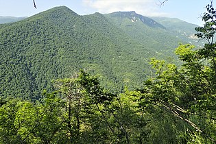 Shikahogh State Reserve seen from the road east from Tsav
 -
 Oriental Plane grove in the Valley of the Tsav River
 -
 WWII monument


References[edit]
Wikimedia Commons has media related to Tsav, Armenia.
- ^ "Syunik regional e-Governance System" (in Armenian). Syunik Province provincial government. Click on link entitled "Համայնքներ" (community) and search for the place by Armenian name.
- ^ a b Statistical Committee of Armenia. "The results of the 2011 Population Census of Armenia" (PDF).
- ^ a b Report of the results of the 2001 Armenian Census, Statistical Committee of Armenia
- ^ Հայաստանի 328 համայնքների միավորմամբ կձևավորվի 34 համայնք. ԱԺ-ն քննարկում է ծրագիրը
- ^ Syunik Province communities
- ^ "Marzes of Armenia and Yerevan City in Figures, 2010" (PDF). Statistical Committee of Armenia.

This article about a location in Syunik Province, Armenia is a stub. You can help Wikipedia by expanding it. |