
Chinari, Armenia
40°50′59″N 45°34′19″E / 40.84972°N 45.57194°E
Chinari
Չինարի | |
|---|---|
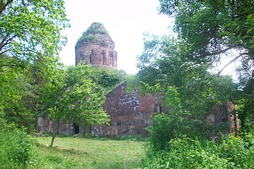
 A view of Chinari and Khoranashat Monastery | |
 Coat of arms | |
 Chinari  Chinari | |
| Coordinates: 40°50′59″N 45°34′19″E / 40.84972°N 45.57194°E | |
| Country | Armenia |
| Province | Tavush |
| Municipality | Berd |
| Elevation | 750 m (2,460 ft) |
| Population | |
| • Total | 887 |
| Time zone | UTC+4 (AMT) |
| Chinari, Armenia at GEOnet Names Server | |
Chinari (Armenian: Չինարի) is a village in the Berd Municipality of the Tavush Province of Armenia. Chinari lies very close to the Armenia–Azerbaijan border, and is the village closest to the abandoned Khoranashat monastery, which lies on a hill northeast of the town, only feet away from the border.
Gallery[edit]
-
 Khoranashat Monastery
 -
 Khoranashat Monastery interior
 -
 Khoranashat Monastery


References[edit]
External links[edit]
Wikimedia Commons has media related to Cultural heritage monuments in Chinari, Tavush.
Capital: Ijevan | ||
| Urban settlements |  | |
| Berd Municipality | ||
| Dilijan Municipality | ||
| Ijevan Municipality | ||
| Noyemberyan Municipality | ||
This article about a location in Tavush Province, Armenia is a stub. You can help Wikipedia by expanding it. |