
Khashtarak
40°56′19″N 45°10′47″E / 40.93861°N 45.17972°E
Khashtarak
Խաշթառակ | |
|---|---|
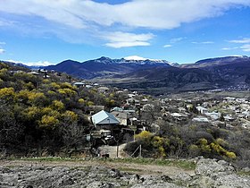
 A view of Khashtarak and surrounding nature | |
 Khashtarak  Khashtarak | |
| Coordinates: 40°56′19″N 45°10′47″E / 40.93861°N 45.17972°E | |
| Country | Armenia |
| Province | Tavush |
| Municipality | Ijevan |
| Population | |
| • Total | 1,771 |
| Time zone | UTC+4 (AMT) |
| Khashtarak at GEOnet Names Server | |
Khashtarak (Armenian: Խաշթառակ) is a village in the Ijevan Municipality of the Tavush Province of Armenia. Within the village is a recently built church, and close by, to the west and the southeast of the village are some abandoned medieval settlements with khachkars.
Education and health care[edit]
There have been several charitable activities organized by the Armenia Fund in Khashtarak in recent times. The medical center of the village, the kindergarten and the public-education school were all renovated by the efforts of diaspora Armenians.
Gallery[edit]
-
 A view of Khashtarak
 -
 St. David Church in Khashtarak
 -
 Houses in Khashtarak
 -
 One of the three cross-symbols of Khashtarak
 -
 A view of Khashtarak and surrounding nature
 -
 A view of Khashtarak
 -
 Landscape around Khashtarak
 -
 WWII monument in Khashtarak


.jpg)


References[edit]
External links[edit]
Wikimedia Commons has media related to Khashtarak.
Capital: Ijevan | ||
| Urban settlements |  | |
| Berd Municipality | ||
| Dilijan Municipality | ||
| Ijevan Municipality | ||
| Noyemberyan Municipality | ||
This article about a location in Tavush Province, Armenia is a stub. You can help Wikipedia by expanding it. |